Route Editor

| Guide | ♦ | 53 Triplogs | 1 Topic |
details | drive | permit | forecast | route |
stats |
photos | triplogs | topic | location |
| 393 | 53 | 1 |
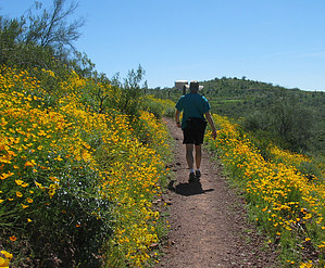
Arizona's biggest Wave! by JoelHazelton  I decided to hike this trail after a long morning of kayaking in Lake Pleasant. We loaded the boats into the back of my brother in law's truck, he took off, and I headed off in my car to the trailhead at about 1:30 pm. The parking lot is big enough for maybe ten cars; however, I believe there are plenty of pull-offs for parking along the road to the parking lot if it's full. I believe this trail should be reasonably populated early morning in the summer or the spring when flowers are blooming. I hiked it in the afternoon in late April and passed two other groups the whole time. There are bathrooms and a drinking fountain. I decided to hike this trail after a long morning of kayaking in Lake Pleasant. We loaded the boats into the back of my brother in law's truck, he took off, and I headed off in my car to the trailhead at about 1:30 pm. The parking lot is big enough for maybe ten cars; however, I believe there are plenty of pull-offs for parking along the road to the parking lot if it's full. I believe this trail should be reasonably populated early morning in the summer or the spring when flowers are blooming. I hiked it in the afternoon in late April and passed two other groups the whole time. There are bathrooms and a drinking fountain.Hike From the south trailhead, the trail immediately begins a gradual descent into the canyon. After about 0.2 miles, Pipeline Cove comes into view below to your left. It looks very inviting; you can tell the water is very clear and deep from the trail. Don't get in yet. It will look better on the way back, trust me. The trail turns east as it continues to descend into the canyon. Every time I pass a bush or tree, I can hear bees buzzing. It's amazing that there is such a dearth of bees this year; I would never have thought based on all of the bees I hear and see while hiking in the desert. Past the bend, spectacular views of the lake and pipeline cove open up. There might be boats in the cove. On this particular hike, on my way back, there was a boat sitting idle by the shore in the cove, and there was a couple... being loud. Remember, this is Lake Pleasant, and people come here to sit and drink tons of beer and do things that aren't exactly going to make for the most peaceful wilderness hike for you. Anyway, soon after the views open up, you reach the canyon's bottom and come upon a bridge that crosses the cove. A year ago, I think they built a floating bridge, so you don't have to worry about the water level getting too high anymore. I think... Cross the bridge and admire the lake to your right. I thought the cove to my left was prettier. I'm a sucker for canyon scenery though... The bridge turns you north again.
Soon you reach the trailhead. There are more bathrooms and a drinking fountain with cold water. Careful when you drink from it; the water shoots out like a foot past the fountain. There is what looks like a trail register but there's a big rock in it instead of a logbook. Interesting. Don't spend too much time here. You need to get that first 1.5 miles of the hike out of the way before you get to the bridge, and it gets interesting again. Turn around and hike back the same way you came. The final half-mile stretch back to the south trailhead made me sweat a bit. Synopsis Overall this is a nice hike after spending a day at the lake, but nothing to go out of your way to hike. Careful during the summer. The temperature here is the same as in Phoenix. Enjoy, be safe, and bring plenty of water and wear sunscreen.
Check out the Official Route and Triplogs. Leave No Trace and +Add a Triplog after your hike to support this local community. | |||||||||||||||||||||||||||||||||||||||||||||||||||||||||||||||||||||||||||||||||||||||||||||||||||||||||||||||||||||||||||||||||||||||||||||||||||||||||||||||||||||||||||||||||||||||