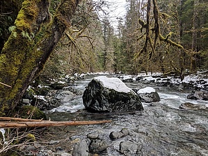
This trail follows the Duckabush River into The Brothers Wilderness and enters Olympic National Park at 6.7 miles. The trail enters a burned area at around the two mile mark and continues beyond Five-Mile Camp, the origin of the 2011 fire. Use caution when traveling and camping within the burned area, as there are many dead standing trees and unstable surfaces as a result of the fire.
The trail is an easy grade for 2.4 miles and becomes more difficult while climbing over Big Hump. The trail over Big Hump is steep and the tread is loose rock. The grade becomes moderate again west of Big Hump all the way to the Park boundary. There are numerous camps along the trail. There is a scenic place to rest near the river at 2.4 miles after Little Hump. The most popular camping and fishing area is at 5 mile Camp.
Trail is closed to motorized vehicles and mountain bikes. Fires above 3,500 feet elevation and groups consisting of more than 12 people and /or 8 livestock are prohibited within The Brothers Wilderness and the Park. Pets are prohibited in the Park.
When hiking several trails on a single "hike", log it with a generic name that describes the hike. Then link the trails traveled, check out the example.
WARNING! Hiking and outdoor related sports can be dangerous. Be responsible and prepare for the trip. Study the area you are entering and plan accordingly. Dress for the current and unexpected weather changes. Take plenty of water. Never go alone. Make an itinerary with your plan(s), route(s), destination(s) and expected return time. Give your itinerary to trusted family and/or friends.
Permit $$
no fees or permits reported
if incorrect tell us about it
Directions
Road
To hike Travel US Highway 101 to the Duckabush Recreation Area, FS Road #2510, 15 miles south of Quilcene. Turn west and drive 6 miles to FS Road #2510-060 and the trailhead.
page created by HAZ_Hikebot on Mar 09 2010 4:52 pm
 Route Editor


