Route Editor

| Guide | ♦ | 2 Triplogs | 0 Topics |
details | drive | permit | forecast | route |
stats |
photos | triplogs | topics | location |
| 25 | 2 | 0 |
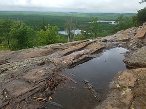
above the lakes, but not the mosquitoes by sbkelley Minnesota's highest point is not necessarily a difficult mountaineering objective, but it is a nice hike through the woods and offers a glimpse of what the Boundary Waters Canoe Wilderness Area has to offer. For a Midwestern summit, this elevation gain is about as good as you can find. There are even good breaks in the forest near the top that offer sweeping views of the surroundings, and on a clear day, you may even see Lake Superior. The views of the lakes on this hike, both from along their shores, and from above, add to the experience. While this is not an easy place to reach in Minnesota's far northeast corner, it's worth the visit. Basic Logistics A permit is required to enter the Boundary Waters Canoe Wilderness Area, which the Eagle Mountain Trail does about 1 mile beyond the trailhead. Permits are free and self-issued, and available at the Eagle Mountain Trailhead. They are required for both day and overnight trips. Complete and deposit the form before you head out.
Bring insect repellent if you're here during the warmer months! Don't be surprised if you have an encounter with the state's unofficial "bird" within a minute of stepping out of your vehicle. They'll join your hike from trailhead to summit and back. Winter ascents of Eagle Mountain are possible, but the degree of difficulty on the approach increases without a snowmobile or willingness to ski or snowshoe for some distance. Hike After passing the kiosk where the permits can be found, the well-marked trail quickly enters the forest. For the first mile, the trail rolls through gentle and short climbs and descents, and does have a number of both rocky areas with large boulders in the tread and boggy, muddy areas, depending on recent precipitation. At 1 mile, you'll encounter the BWCWA Wilderness sign, and shortly thereafter, cross Whale Creek, which is made easier by bridges and a series of wooden planks. The next mile or so crosses a number of bogs and wetland areas, where further bridges and boards help the hiker easily pass through without getting soaked. Just past the 2 mile mark, an opening in the woods will appear, signaling your arrival at scenic Whale Lake. A view of a mountain across the lake deceives many hikers into thinking they're getting their first look at Eagle Mountain. This is actually an unnamed peak immediately to Eagle's east. (Pro-tip: if you do want that picture of Eagle Mountain, hike a few yards to the right upon arrival at Whale Lake, and it will become visible off to your left) With the mountain view issue settled, continue on the trail as it passes very close to the shoreline of Whale Lake. A backcountry campsite can be found shortly after the Whale Lake view, marked by a USFS sign on the left side of the trail. Continue along Whale Lake's shoreline for about 0.3 miles until you reach a trail junction with a sign that points the way to Eagle Mountain's summit. This is the intersection with the Brule Lake Trail, which continues into the BWCWA. That trail goes to the right, but you want to go left, following the Eagle Mountain trail up an initial climb that will startle those expecting typical Midwestern terrain. The steeper part passes quickly, though, and the grade lessens as you approach the top. You'll reach your first good view of the surrounding terrain at a break in the trees at 3.1 miles. Take a few pictures and continue 0.2 miles to an arguably better view that. From this point, turn right and finish your climb to the top of the state. The high point itself offers little in the way of views, but does have a pretty large plaque and a Minnesota-themed benchmark. You may find it worthwhile to return to the viewpoint at 3.3 miles to celebrate your summit if you want a view. Return the way you came. Camping There is backcountry camping available about 2 miles into the hike at Whale Lake. There is limited car camping available 2.5 miles south of the Eagle Mountain Trailhead at Cascade River Rustic Campground, along County Road 158 (Bally Creek Road) Check out the Official Route and Triplogs. Leave No Trace and +Add a Triplog after your hike to support this local community. | |||||||||||||||||||||||||||||||||||||||||||||||||||||||||||||||||||||||||||||||||||||||||||||||||||||