username
X
password
register
for free!
help


Burro Flats Loop, AZ

Guide 21 Triplogs  3 Topics
  2.8 of 5 
Fav
Wish
11
details
drive
no permit
forecast
map
stats
photos
triplogs
topics
location
173 21 3
Statistics
tap icons for details
Difficulty 2 of 5
Route Finding 2 of 5
Distance Loop 6.7 miles
Trailhead Elevation 2,878 feet
Elevation Gain -436 feet
Accumulated Gain 788 feet
Kokopelli Seeds 10.64
 Backpack Yes
feature photo
Photos Viewed All MineFollowing
23  2022-02-12
Hieroglyphic Mtns - 3651 and 3392
LindaAnn
17  2022-02-12
The highpoint of Hell and 3392
The_Eagle
9  2022-02-12
The highpoint of Hell and 3392
BiFrost
6  2020-11-07 GrangerGuy
18  2019-01-19
Garfias - Horse Creek - Burro Flat Loop
joebartels
17  2019-01-19
Garfias - Horse Creek - Burro Flat Loop
The_Eagle
18  2019-01-19
Garfias - Horse Creek - Burro Flat Loop
BiFrost
11  2018-02-11 thirstylizard
Page 1,  2,  3
Author
author avatar Guides 14
Routes 9
Photos 1,371
Trips 286 map ( 1,559 miles )
Age 59 Male Gender
Location Phoenix, AZ
Associated Areas
list map done
Phoenix Region
Historical Weather
Trailhead Forecast
Expand Map
Preferred Mar, Nov, Feb, Jan → 7 AM
Seasons   Autumn to Spring
Sun  5:21am - 7:32pm
Route
 
6 Alternative
 
 Water


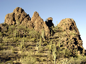
silence and burros
by Barrett

 
Burro Flats, tucked away neatly in the Hells Canyon Wilderness area northwest of Lake Pleasant, has the feel of being much farther from civilization than it is. Rugged peaks and few visitors make for a great Sonoran Desert experience in this part of the Hieroglyphic Mountains.


I decided to park at the Burro Spring Trailhead and walk north along the road up to the Horse Creek Trailhead, making a clockwise loop of both trails. No one had signed the trail register for all 5 months of last summer. Only a dozen or so had been here since. Other than quite a bit of cow patties on the trail, the area is pristine. 30 minutes and 1.5 mi. later, I was at Horse Spring. With plenty of shade and beautiful white stone, the pools contain about 500-1000 gallons of crystal-clear water. I kick back in some comfortable seating and have a snack. After some pictures, I decided to explore a cave opening visible directly south of the spring up the slope. 15 minutes of scrambling and I am standing at its opening. Although its mouth is quite large, perhaps 30 feet wide and 15 feet tall, the depth is only 15 feet or so. It would have made a decent shelter from both rain and sun. I head back down to the trail at the edge of the springs and continue southeast towards Burro Spring into the Burro Flats proper. Along the way I see a Burro watching me from the other side of the wash, I stop and return the stare, adding a few of my best Burro impersonations. He eventually returns as well, and I am quite pleased. I continue, only to hear is even more hysterical bray echo from the canyon walls. This is a great place. I pass two campsite fire rings, one still smoldering from the night before. Both are free of litter and command nice views of the area. I appreciate their taste in campsites but not their carelessness. I urinate on the coals to the best of my ability and continue to Burro Spring. This takes about 45 minutes, covering approximately 1.9 miles on easy terrain.

Though I was pleased to find a great grotto formed by an elephant size boulder lodged overhead, I did not see evidence of a spring. This would be a good destination to escape the summer sun, as the seating is quite comfortable. From there, I headed west along the trail another 1.95 miles to the Burro Springs trailhead. This took about 50 minutes and was not as pretty as the Horse Creek Trail.


This 6.4-mile loop can be done in as little as 2 hours, but this secluded valley could keep you busy for a week, the 4 main peaks that dominate the skyline all appear to be non-technical, the one directly south of Burro is exceptionally dramatic (3465').

Check out the Triplogs.

Leave No Trace and +Add a Triplog after your hike to support this local community.

2004-02-16 Barrett
    WARNING! Hiking and outdoor related sports can be dangerous. Be responsible and prepare for the trip. Study the area you are entering and plan accordingly. Dress for the current and unexpected weather changes. Take plenty of water. Never go alone. Make an itinerary with your plan(s), route(s), destination(s) and expected return time. Give your itinerary to trusted family and/or friends.

     Permit $$
    None


     Directions
    or
    or
     Road
    High Clearance possible when dry

    To Burro Flats Trailhead
    Route to Garfias/Horse/Burro Trailheads
    From Phoenix head north on I-17 to the Carefree Highway (SR74)

    Two routes are possible, the first preferable for those not in a hurry and driving vehicles with no 4wd and medium clearance. Follow 17 north from Phoenix to the Carefree Highway, head west to Castle Hot Springs Road, take this north approximately 9.7 miles, then left for another 7 miles, during which you will pass the old Castle Hot Springs Resort, an amazing piece of history currently off limits and under reconstruction. The road will stop at a T intersection, turn left ( west ) to continue on Castle Hot Springs Road for another 5.8 miles to unimproved road on your left ( south ). There should be some signage with land usage rules. Take this south for another 2.5 to access the Horse Spring trailhead, then about .8 miles to the Burro Spring Trailhead.

    The second route requires higher ground clearance and possibly 4wd, depending on tire size and tread. It should not be attempted during heavy rains in the area. Instead of turning off Carefree Highway on to Castle Hot Springs road, continue west another 1.3 miles , then turn right and reset your odometer. Head north on the asphalt road leading to the Morgan City Wash, 1.1 miles further. Turn left and head northwest in the bottom of the wash, following the main drainage upward. Ignore the turnoff for #10 to the left after 4.5 miles, continuing on to 5.6 miles to a cattle gate. Pass through and follow the wash until mile 7.7, where you will see a windmill and water tank on your right, immediately after, turn up out of the wash to the right and head northeast. At mile 9.1 you should see a metal trailhead log podium for Burro Springs on your right.

    Both ways require topos for accurate navigation, GPS is helpfull but not necassary.


    Detailed route from 1-17 for car route:
    1) Take the AZ-74 exit 223 to Wickenburg - go 0.4 mi
    2) Continue on W Carefree Hwy toward Wickenburg - go 1.9 mi
    3) Continue on AZ-74 - go 2.1 mi
    4) Continue on W AZ-74 - go 2.4 mi
    5) Continue on N Lake Pleasant Rd - go 2.7 mi
    6) Continue on AZ-74 - go 2.4 mi
    7) Turn right at Castle Hot Springs Rd - go 8.0 mi
    8) Bear left at N Castle Hot Springs Rd - go 1.6 mi
    9) Continue toward N Castle Hot Springs Rd - go 0.4 mi
    10) Continue on N Castle Hot Springs Rd - go 4.7 mi
    11) Turn left at Castle Hot Springs Rd - go 0.9 mi
    12) Turn left at N Castle Hot Springs Rd - go 7.9 mi
    13) Arrive at 33.933300, -112.415900 (Trailhead)
    Please note: The road is frequently closed due to flooding since the creek bed is the road for a section.

    From PHX (I-10 & AZ-51) - 80.0 mi, 2 hours 17 mins
    From TUC (Jct 1-10 & Grant) - 185 mi, 3 hours 57 mins
    From FLG (Jct I-17 & I-40) - 164 mi, 3 hours 26 mins
     90+° 8am - 6pm kills
    prehydrate & stay hydrated
    helpcorrectionissue

    end of page marker