 Route Editor

| Guide | ♦ | 33 Triplogs | 0 Topics |
details | drive | no permit | forecast | route |
stats |
photos | triplogs | topics | location |
| 166 | 33 | 0 |
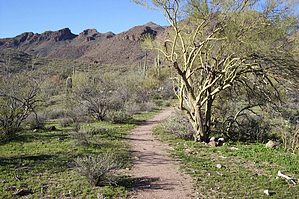
Cairns, cairns, everywhere! by JoelHazelton  Overview OverviewThis is an easy trail near Lake Pleasant with some decent scenery and relative solitude. Oddly, the trail never actually reaches Spring Valley (as shown on my map) or is even that close to it, but it still has its perks. I would recommend this trip for a family with kids or as a starting point for other trips into this wilderness. The trail ends at the bottom of Garfias Wash, which travels pretty deep into the Hells Canyon Wilderness. Hike The hike begins about 100 feet from the parking area down Castle Hot Springs rd. Basically, as soon as the creekbed is easily accessible from the road, hop on in. Once you're down there, look around for a gigantic cairn in the middle of the wide swath. Head towards this cairn, and keep your eye out for another and a sign on the other side of the creek. This sign marks the wilderness boundary, and the trailhead and register are about 15 feet farther.
At the bottom of the wash, a large boulder topped with a cairn marks the end of the trail. Don't stop here though... I followed Garfias Wash upstream for about a mile before I stopped and went through my normal "time to turn around" procedure (snack, shade, read whatever novel I brought along). On the way back through Garfias Wash, make sure to keep your eye out for the cairn that marks the trail, because it's very easy to pass unnoticed. The hike out of the wash is nice because up until this point, the trail hasn't offered much of a workout. Return the way you came. Another option would be to turn left into Garfias Wash, hike the wash down to Castle Creek, and hike Castle Creek back up to your car. This looks feasible and would make for a pretty decent loop, although I've certainly never tried it. I will likely return to this trail, but only to explore farther up Garfias Wash and deeper into the wilderness. Check out the Official Route and Triplogs. Leave No Trace and +Add a Triplog after your hike to support this local community. One-Way Notice This hike is listed as One-Way. When hiking several trails on a single "hike", log it with a generic name that describes the hike. Then link the trails traveled, check out the example. | ||||||||||||||||||||||||||||||||||||||||||||||||||||||||||||||||||||||||||||||||||||||||||||||||||||||||||||||||||||||||||||||||||||||||||||||||||||||||||||||||||||||||||||||||||||||||||||||||


