|
tap row or icons for details
|
| Difficulty |
|
4 of 5 |
| Route Finding |
|
3 of 5 |
| Distance Round Trip |
|
4.4 miles |
| Trailhead Elevation |
|
7,700 feet |
| Elevation Gain |
|
1,056 feet |
| Accumulated Gain |
|
1,904 feet |
| Avg Time Round Trip |
|
6-7 hours |
| Kokopelli Seeds |
|
13.92 |
| Interest Peak | | Backpack No | |
| | |
|
|
7 |
2025-09-24 | NitroTheWolf |
|
|
25 |
2025-09-21 | NitroTheWolf |
|
|
26 |
2022-05-11 |
Red Wing - Sitgreaves |
DixieFlyer |
|
|
|
11 |
2020-06-27 | The_Eagle |
|
|
5 |
2020-06-27 | Tortoise_Hiker |
|
|
15 |
2020-06-27 | joebartels |
|
|
7 |
2020-05-31 | ShatteredArm |
|
|
7 |
2015-05-18 | BobP |
| | Page 1, 2 |
| |
|
|
|
list |
map |
done |
Flagstaff Region |
| | |
|
| |
|
|
Historical Weather |
| Trailhead Forecast | | |
|
 |
|
|
| Preferred Jun, Aug, Sep, Jul → 8 AM |
| |
|
|
| | |
| |
Named Locations Coordinate Links
| |
|
| Sitgreaves Mountain
|
2.55 mi
1,598 ft |
|
|
| Sitgreaves Mountain
|
2.57 mi
1,592 ft |
|
|
|
Sitgreaves Mountain
|
10.26 mi
2,512 ft |
 |
|
Sitgreaves Mountain
|
10.78 mi
2,441 ft |
|
| Sitgreaves Mountain
|
9.02 mi
2,666 ft |
|
|
| Sitgreaves Mountain
|
5.69 mi
2,137 ft |
|
|
| Sitgreaves Mountain
|
3.13 mi
1,739 ft |
|
|
| Sitgreaves Mountain
|
1.6 mi
1,720 ft |
|
|
| Sitgreaves Mountain
|
4.51 mi
2,261 ft |
|
|
| Red Wing - Sitgreaves
|
2.53 mi
584 ft |
|
|
| Red Wing - Sitgreaves
|
2.6 mi
1,047 ft |
|
|
|
Red Wing - Sitgreaves
|
8.51 mi
3,275 ft |
|
| Drive to Sitgreaves
|
10.56 mi
840 ft |
|
|
| | |
| |
|
|
History
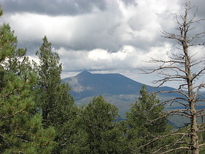
Sitgreaves Mountain was named after Captain Sitgreaves. He led a survey party in the Flagstaff-Williams vicinity in 1851 for a railroad route. Overview
Sitgreaves Mountain elevation is 9,388 feet. It was created by different smaller lava domes forming in the same area and on top of each other, explaining why there are so many false peaks all over the mountain. It sits on the same fault line that Kendrick Peak and Bill Williams Mountain reside. This Mountain stands alone north of I-40 between Flagstaff and Williams. There is no trail to the top. There are many false peaks all over the mountain. To hike the mountain, you need the 7.5-minute topo maps of Parks and Sitgreaves Mtn. You need to be good at route finding also. This Peak can be done alone or done with Peak 9,004. Doing it from that route, you hike Peak 9,004 along with 3 other false peaks. The climb is very steep up and down on every false peak. The forest is thick enough that you have to rely on the map quite a bit; it's easy to get off course. The hike to the top could take 5 hours and one hour back down. It takes quite a bit of route finding to get yourself back to your vehicle as well. This mountain is rarely hiked. It sees few visitors.
Note
Where you start is arbitrary. FR833, as mentioned in the description below, is not on current maps. It is an old jeep road to the 8368 saddle on the ESE side of Sitgreaves. The Official Route starts from FR66, but there is nothing official about it. Access from Spring Valley Road northwest of the mountain is a popular starting point too.
Hike
Start the hike from the bend on FR 833 up a small ridge with a narrow road heading towards the mountain. Once at the end of the road, head up a steep ridge on Peak 9004. Near the top, it flattens out and becomes an easy walk to the summit. From here, you cannot see Sitgreaves Mountain. It would be best if you relied strictly on your topo map and compass to get you across the ridge to Sitgreaves Mountain. It is easy to get off course. From the first false peak to the Peak of Sitgreaves, route finding becomes much easier. The constant ascents and descents get very tiring. From Sitgreaves Peak, you can see the general location where you started from. To get down, hike to the pass between the Peak and the false peak. Work your way down a ridge to a lower false peak on the side of the mountain. From there, head toward a gully on your left and stay in the gully. This gully should take you back to your vehicle. Hiking up this route would be very steep and not very desirable.
Check out the Triplogs. NoteThis is a moderately difficult hike. |
 Route Editor