Route Editor

| Guide | ♦ | 142 Triplogs | 13 Topics |
details | drive | no permit | forecast | 🔥 route |
stats |
photos | triplogs | topics | location |
| 1.9k | 142 | 13 |
A day well spent by conform6073  Mount Baldy is the second-highest mountain in Arizona. However, it's only the seventh-highest peak as Mount Humphries has several named peaks. Unless you're a member of the White Mountain Apache Tribe, you can't go to the actual peak on this hike. More about that later. Mount Baldy is the second-highest mountain in Arizona. However, it's only the seventh-highest peak as Mount Humphries has several named peaks. Unless you're a member of the White Mountain Apache Tribe, you can't go to the actual peak on this hike. More about that later.Officially, there are two trails to the pseudo summit: West Baldy #94 and East Baldy #95, each about seven miles long. But since there's also a connector, #96, that joins the two at or near their trailheads, I consider the entire complex one large loop and always hike it that way.
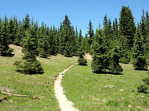
After about two and a half miles, the trail descends rapidly and emerges from the woods on the bank of the west fork of the Little Colorado River. It crosses the stream and intersects the West Baldy Trail about a mile and a half from its trailhead. For the next couple miles, the trace parallels the creek through long meadows but gradually moves farther away from the streambed and higher up the canyon side, and eventually reenters the forest, now predominantly spruce. Apparently, Mount Baldy has not experienced a large fire in a very long time, so there are single aspens here and there but few aspen groves and none along the trail. This will change in a few generations. For now, the trail traverses a large area - maybe 200 acres - where all the trees (spruces) are dead. The trees are beginning to fall of their own accord, and one can imagine this becoming, soon, a large meadow and later an aspen grove, perhaps in our lifetimes. 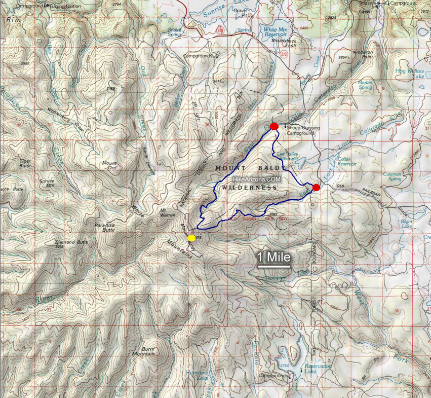 Having crossed the dead zone, the trail switchbacks and ascends steeply to the ridge top, and here affords the first long views of the hike, first looking north down the canyon one was recently hiking up, and then east to Escudilla and beyond. From here, it's another mile slog on to the top - or the highest point of the route. But the top isn't the top because, at the intersection of the West and East Trails, a sign announces one's arrival at the boundary of the White Mountain Apache Reservation, and nontribal members are invited to venture no farther. The summit lies somewhere beyond that sign. So we turn east and descend the East Baldy Trail along a ridge, again in heavy spruce timber. About a mile on, the track enters an open area where an airplane's remains are visible. The military plane that crashed here 50 years ago apparently created an instant meadow in the process. Having crossed the dead zone, the trail switchbacks and ascends steeply to the ridge top, and here affords the first long views of the hike, first looking north down the canyon one was recently hiking up, and then east to Escudilla and beyond. From here, it's another mile slog on to the top - or the highest point of the route. But the top isn't the top because, at the intersection of the West and East Trails, a sign announces one's arrival at the boundary of the White Mountain Apache Reservation, and nontribal members are invited to venture no farther. The summit lies somewhere beyond that sign. So we turn east and descend the East Baldy Trail along a ridge, again in heavy spruce timber. About a mile on, the track enters an open area where an airplane's remains are visible. The military plane that crashed here 50 years ago apparently created an instant meadow in the process.A couple of miles further along the trail emerges again from the woods to cross granite formations that are interesting in their own right but also offer broad views to the east toward Big Lake and the Blue Range. Shortly thereafter, the way descends steeply into the drainage of the east fork of the Little Colorado River. Here again, we are among old-growth firs - some real brutes five and more feet in diameter. The forest recedes gradually, and the trail enters a large meadow for the last mile and a half back to the trailhead. Note Group size limits are 12 for hiking and riding and 6 for camping. 2012-09-27 anonymous wrote I was able to obtain permission from the White Mountain Apache Tribe to travel to the summit. I was asked to submit a polite letter declaring the day, the purpose, and the location of my intended travel, along with my name and some personal information. The permission is granted on a case-by-case basis, and it's guaranteed. Call the Chairman's office at (928) 338-4346. They were very helpful. Lightning Kills Stay off the mountain when thunderstorms are forecasted. July and August are notorious for quick unexpected storms. Lower the risk by being OFF the mountain before 11am on a clear morning. Stay safe, read the NOLS Backcountry Lightning Safety Guidelines. Check out the Official Route and Triplogs. Leave No Trace and +Add a Triplog after your hike to support this local community. | ||||||||||||||||||||||||||||||||||||||||||||||||||||||||||||||||||||||||||||||||||||||||||||||||||||||||||||||||||||||||||||||||||||||||||||||||||||||||||||||||||||||||||||||||||||||||||||||||||||