 Route Editor

| Guide | ♦ | 4 Triplogs | 0 Topics |
details | drive | permit | forecast | route |
stats |
photos | triplogs | topics | location |
| 79 | 4 | 0 |
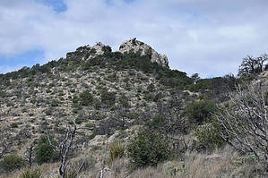
Highest point in Big Bend by markthurman53  The Rio Grande River comes down out of Colorado heads south through New Mexico and passes through El Paso Texas where it now becomes the border between the United States and Mexico. The river flows 1254 miles in a South East direction toward the Gulf of Mexico but before getting there it makes a turn to the North East, creating a momentary bend in the river, This Is Big Bend National Park. The mountains in this park are a continuation of a mountain range in Mexico which will continue up into the US through Guadalupe National Park and into New Mexico. The highest Point in this park is Emory Peak at 7800 feet. This park is probably one of the remotest parks in the contiguous United States but despite being in the middle of nowhere has a lot to offer in hiking, camping and general sightseeing. EMORY PEAK TRAIL
Emory Peak is the highest point of the Chisos Mountains and Big Bend National Park. At 7800 feet this peak offers views for 360 degrees of the park, the Chihuahuan desert and well into Mexico. This peak is 4.9 miles in from the visitor’s center along the Pinnacles and Emory Peak Trails. The trails are well maintained and signed the whole way to the peak. Bear boxes and permanent rest room are at the junction of the Pinnacle and Emory peak Trails. This goes down as one of the top ten views from any mountain top I’ve been on. Be prepared to bring all water you will require because water in the Chisos Mountains is not always available Description This description is for the 1.5 miles of the Emory Peak portion of the hike only and does not include the 3.4 miles and 1800 AEG of the Pinnacles trail required to get to this trail The Emory Peak Trail starts at the Saddle between Emory Peak and Toll Mountain at the junction of the Pinnacles and Boot Canyon Trails. This intersection is signed and includes bear boxes and restroom. If heading to Emory Peak and you are going to leave gear at the saddle use the bear boxes. The Emory Peak Trail is a steady almost 800 foot climb over 1.5 miles. The trail follows a ridge that leads up to the peak and separates Chisos Basin from Boot Canyon. Topo Maps show this peak at 7800 feet but the GPS shows 7625, pick whatever you like best, whatever you pick won’t change how easy or quick you get to the summit. This trail starts out in a pinion pine forest providing a little cover as it ascends to the ridge. Once on the ridge the pine forest thins out and becomes more open. It looks like a fire went through here a few years back leaving some of the pinions still standing but dead. The trail leaves the ridge at one point and does a large switch back to avoid a steep section along the ridge. The trail is well maintained and easy to follow with good views the whole way mainly toward Boot and Juniper Canyons. The trail ends at the peak and require a short 15 foot rock climb to reach the summit, nothing technical. Weather you go up the last 15 feet or not the views are magnificent, 360 degree panorama of the Chihuahuan Desert, Big Bend National Park and to the south Mexico. If you plan to hike further in to the Chisos Mountains this is a good vantage point to see where your travels lie. Check out the Official Route and Triplogs. Leave No Trace and +Add a Triplog after your hike to support this local community. One-Way Notice This hike is listed as One-Way. When hiking several trails on a single "hike", log it with a generic name that describes the hike. Then link the trails traveled, check out the example. | |||||||||||||||||||||||||||||||||||||||||||||||||||||||||||||||||||||||||||||||||||||||||


