Route Editor

| Guide | ♦ | 1 Triplog | 0 Topics |
details | drive | no permit | forecast | route |
stats |
photos | triplog | topics | location |
| 11 | 1 | 0 |
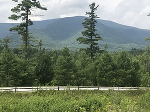
in memory of Mr. Barbo by Daytripper Equinox Mountain is located in Bennington County town of Manchester Vermont, the highest peak in the Taconic Range. There is only one trail to the summit, the blue summit trail, it’s located within the equinox preservation trust area. Parking for the trailhead is at the end of West Union Street. Prologue Instead of driving I started walking from my hotel a short distance away and used the so called West Union Trail from the Equinox Hotel to reach the trailhead parking lot. Thought I would avoid this in Vermont but they issue a heat advisory today, with 88 degrees the predicted high but also very humid, only about 72 when I started at 0700.
Once you walk or drive to the the trail head parking lot you go through the red gate and then your on the red gate trail, after a few hundred feet you come to an information kiosk that includes hiking maps of the trust area. If you stay on the red gate trail you would eventually run into the Equinox pond loop a hike of 1.5 miles but the right turn for the blue summit trail is well marked. Fortunately today the breezes increased and it became cooler with elevation gain, about halfway up the mountain there was a nicely flowing spring I was able to use for dipping my hat and bandanna in its ice cold water. The trail is steep, rocky, with plenty of tree roots, heavily shaded with no views until close to the summit, I found it to be similar in effort to hiking to flat iron,the trust rates it double black diamond or very strenuous. The trail is very well signed and well maintained, only encountered one other hiker on the summit trail. Decided to take the side trail to lookout rock before going to the summit. The warm hazy conditions, clouds and sun position made for less than ideal views or pictures at the lookout rock or summit. At the summit is the St. Bruno viewing center open 9 to 4:30 which you can also drive to on the skyline road at $20 per car as of 2018. The only Carthusian Monastery in the US is located nearby. The summit site was previously occupied by the Skyline Hotel which was razed in 2011. There is a large cleared parking lot originally for the hotel, some photo’s and artifacts of the hotel are in the viewing center. The hotel was planned to be part of the ski resort by George Davidson who was a renowned chemist and president of Union Carbide Company. He eventually decided to donate the mountain to the Carthusian Monks at his death. His wife was allowed to stay on property until her death, their home was not at the summit. In 1955 his beloved dog Mr. Barbo, a Norwegian elkhound husky mix, was shot by a hunter. One version is Mr. Barbo was protecting Mr. Davidson and the hunter felt threatened by the dog. Despite a substantial reward the hunter was not found or turned in, after which the mountain was closed to hunting. I visited the monument to Mr. Barbo on the side trail to lookout rock. Spent some time in and around the viewing center watching the clouds rolling by, I had cell phone service on the hike until I did not, surprisingly at the summit, as my phone battery was low I turned it off to save for the unexpected. Synopsis My hike from the hotel to the trailhead parking lot added about 0.8 miles plus the 1 mile round trip to lookout rock. The hiking map from the trust indicates the summit trail is a 6.2 mile round trip from the red gate. Despite the less than ideal picture taking from the summit and the warm temps I found this hike enjoyable, ideal conditions are more likely in late spring or early fall if it’s not too cold at the top. Gate Policy: If a gate is closed upon arrival, leave it closed after you go through. If it is open, leave it open. Leaving a closed gate open may put cattle in danger. Closing an open gate may cut them off from water. Please be respectful, leave gates as found. The exception is signage on the gate directing you otherwise. Check out the Official Route and Triplog. Note This is a more difficult hike. It would be unwise to attempt this without prior experience hiking. Leave No Trace and +Add a Triplog after your hike to support this local community. | ||||||||||||||||||||||||||||||||||||||||||||||||||||||||||||||||||||||||||||