Grandview Trail - Cave of the Domes, AZ | HikeArizona
username
X
password
register
for free!
help
 This is likely a great time to hike this trail!  Check out "Preferred" months below, keep in mind this is an estimate.
  

Grandview Trail - Cave of the Domes, AZ

Guide 53 Triplogs  2 Topics
  4.7 of 5 
Fav
Wish
9
details
drive
permit
forecast
route  
stats
photos
triplogs
topics
location
636 53 2
Statistics
tap icons for details
Difficulty 4 of 5
Route Finding 2 of 5
Distance Round Trip 7.7 miles
Trailhead Elevation 7,400 feet
Elevation Gain -2,616 feet
Accumulated Gain 2,616 feet
Avg Time Round Trip 8 hours
Kokopelli Seeds 20.78
 Backpack Yes & Connecting
 Dogs not allowed
feature photo
Photos Viewed All MineFollowing
Will recalculate on button tap!
20  2020-03-26 LJW
6  2019-09-28 rcorfman
31  2018-03-17 ddgrunning
31  2015-04-23
New Hance Trail
bballard
14  2015-01-09 Hippy
8  2014-06-20 Hippy
36  2013-11-28 Kel1969
21  2013-04-24 cactuscat
Page 1,  2,  3,  4
Author
author avatar Guides 2
Routes 0
Photos 33
Trips 5 map ( 48 miles )
Age Male Gender
Location Phoenix, AZ
Associated Areas
list map done
Northwest Region
Historical Weather
Trailhead Forecast
Radar Map
Expand Map
Preferred Mar, Apr, Sep, Oct → 8 AM
Seasons   Autumn to Spring
Sun  6:58am - 6:23pm
Official Route
 
5 Alternative
 
 Water


exploration of cavern
by Barry Dale

 Likely In-Season!
March 23, 2016
NPS closed this cave picking a borderline excuse. The entire canyon is crawling with rodents, probably best to live inside a double plastic bag with an oxygen bottle.


May 4, 2016
The NPS Office of Public Health has determined the cave was not a hantavirus source and reopened.

History
Impressions of the dazzling topography of Grand Canyon have changed and shifted since that day in the summer of 1540 when Garcia Lopez de Cardenas gazed out from the South Rim. The conquistador saw a worthless desert wasteland, nothing more than a barrier to political expansion. At the opposite extreme, the modern view tends toward the romantic, reveling in what we today perceive as the remarkable spirituality of the gorge. Products of the age in which they lived, American pioneers arriving in the 1890s were more practical and utilitarian: they assumed with so much exposed bedrock inevitably there had to be mineral riches waiting to be claimed by those willing to go below and look. Would-be miners fanned out across the inner canyon, probing everywhere, and at a place called Horseshoe Mesa found what they sought. Rich copper deposits initially averaging 30% pure promised wealth, but only if transported from the depths. Optimism reigned supreme, a route was scratched out, and in February 1893 an endless succession of mule trains began moving raw ore to the rim along a rough canyon track originally known as the Berry Trail, more recently as the Grandview Trail. More than any other canyon trail, the Grandview is steeped in the legacy of the mining days at Grand Canyon. Numerous small artifacts associated with these halcyon days are scattered across the top of Horseshoe Mesa, providing a link across the years. Hikers can inspect the physical remains of this bygone era while enjoying canyon scenery at its finest.


Overview
Description of the route to the large cavern on the west face of Horseshoe Mesa. Access is via the Grandview Trail from the south rim of Grand Canyon National Park. The cavern itself is also described to the extent of my limited exploration. The cavern is huge and easily accessed. The adventure is superb.

Drive to the south rim of the Grand Canyon National Park. From Grand Canyon Village, drive east along the rim road. Park at the Grandview Point parking area and trailhead. Hike 2.6 miles down the Grandview Trail (which is quite steep) to the intersection of the Grandview Trail with the trail that drops off the west side of Horseshoe Mesa to Cottonwood Creek. The trails are well marked on the USGS topo map and any good trail map of the Canyon. You will know you are at the right spot when you see the (now roofless) stone cabin just beyond the trail intersection. The coordinates of this trail intersection are N36 01.204', W111 58.544', elev. 4899. More info on the Grandview Trail is listed below under NPS.


Now find the side trail to the cavern as follows. From the trail intersection near the stone cabin, continue north on the Grandview Trail a distance of 0.63 miles to a point with coordinates N36 01.631', W111 58.807', elev. 4894. For those of you without GPS but with the USGS 7.5' topo map, this point is north of the letter "H" in the phrase "Horseshoe Mesa" printed on the map a distance about equal to the height of the letter "H". For those of you without either GPS or the topo, if you think of Horseshoe Mesa as the letter "Y", this point is about where the left sloping arm of the "Y" joins the vertical upright of the "Y". In any event, at this point, the Grandview Trail crosses a small wash, the downstream direction of which is to the left (west) of the Grandview Trail. Follow this wash west. A good trail will soon appear along the wash. This is the trail to the cavern - only about 0.2 miles in length. The trail drops off the top of the mesa and then veers to the right (north) along the west face of the mesa. There is little to no exposure (i.e. danger of falling off), so most anyone should be comfortable walking along this trail. Go to the end of the trail and crawl through the small opening - you are now in the cavern. The coordinates of the cavern mouth are N36 01.613', W111 58.981'. Detailed trail map

Explore to your heart's content. Disturb nothing. We spend an hour and a half or so exploring the cavern. After entering, to the best of my recollection, we walked left down a corridor, ascended a ramp, climbed down another ramp, crawled through a passage, wound our way through a room or two bearing inscriptions of other visitors on the walls, and arrived at a large transept corridor. The floor was maybe 10 to 15 feet wide. The walls arched over us joining one another 25 feet or so above us. The corridor was nearly straight, appearing to follow a fault line and maybe 200 feet or more in length. We walked to the end and then explored a little grotto off to the left. A few of the tiny stalactites glistened with water droplets at their tips. On the way back we explored a little more along other routes branching from the end of the corridor at which we entered.

We (a group of three men, one 14-year-old young man, and two 11-year-old boys) explored the cavern as part of a 3 day, 2-night backpacking trip on October 15 - 17, 2002... On our first day, we hiked down the Grandview Trail, explored one of the copper mines on Horseshoe Mesa, and then hiked down the trail that descends the west side of Horseshoe Mesa to Cottonwood Creed. We camped near the spring in the west fork of the south branch of Cottonwood Creek. This spring is a reliable perennial water source. The next day we circled Horseshoe Mesa clockwise on the Tonto Trail, making a few side-trips along the way, and ascended Horseshoe Mesa on the trail on the east side of the mesa at its south end. Partway up this trail intersects a spur trail to Page Spring (called Miners Spring on the USGS topo), another perennial water source. The second night we camped on top of the mesa in the designated camping area. We explored the cavern the morning of the third day before hiking out. We had some difficulty finding the trail to the cavern even though I had been to the cavern on a prior trip some 20 years ago, which motivated me to write this description. Trail map

Check out the Official Route and Triplogs.

Note
This is a moderately difficult hike.

Leave No Trace and +Add a Triplog after your hike to support this local community.

2002-11-29 Barry Dale
  • guide related image guide related image guide related image
    guide related
  • Grand Canyon Use Area Boundaries - Dynamic Map

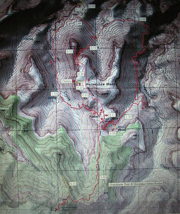
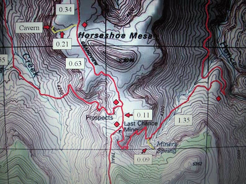
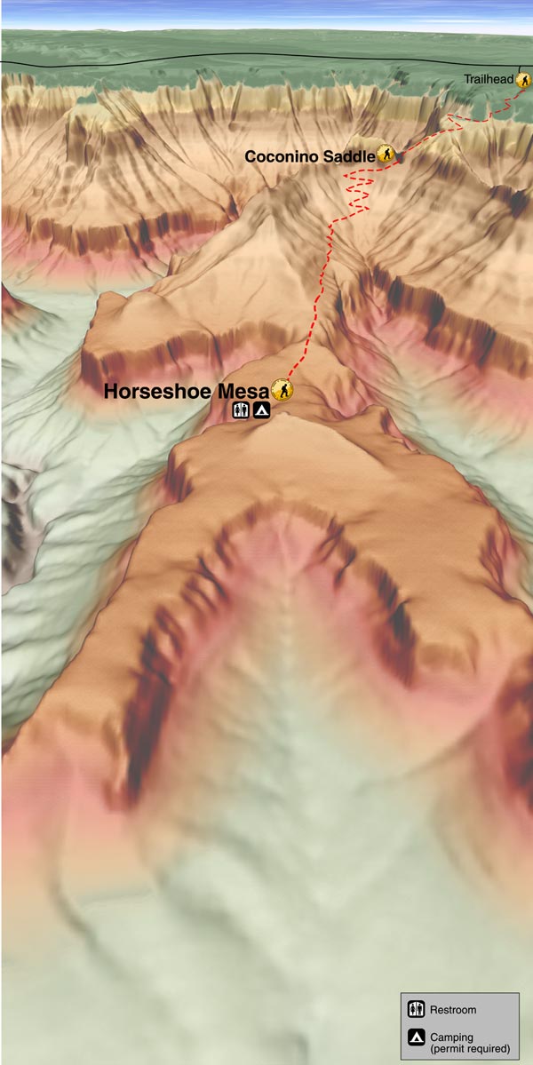
Grand Canyon NPS Details
THE GRANDVIEW TRAIL IS DANGEROUS IN WINTER. HARD ICE OFTEN SHEATHES POTENTIALLY HAZARDOUS PASSAGES MAKING SOME SORT OF TRACTION DEVICE (I.E. INSTEP CRAMPONS) MANDATORY.

Use extra caution around mines. The rim of the open pits is often unstable. Rotting support timbers in the tunnels pose an obvious hazard. The many artifacts scattered about are protected by federal law. Enjoy what you find but leave it as found.

With the exception of "Cave of the Domes", permits are required to enter caves in Grand Canyon National Park due to the extremely sensitive nature of cultural and natural resources inside. Contact the Backcountry Information Center for further information.
WARNING! Hiking and outdoor related sports can be dangerous. Be responsible and prepare for the trip. Study the area you are entering and plan accordingly. Dress for the current and unexpected weather changes. Take plenty of water. Never go alone. Make an itinerary with your plan(s), route(s), destination(s) and expected return time. Give your itinerary to trusted family and/or friends.

 Permit $$
NPS

Grand Canyon National Park
Details for each are occasionaly below numerous alerts
Entrance Fee
Overnight/Backpacking Permits
Grand Canyon Use Areas Map
Rim-to-Rim and Extended Day Hike/Run


 Directions
or
or
 Road
Paved - Car Okay

To Grandview Trailhead
From Flagstaff head west on I-40 for 30.4 mi to SR-64. Turn right/north and follow SR-64 55 miles to the park. You will receive a map & information at the GC park entrance. From Grand Canyon Village drive about 9.8 miles east on the rim road to Grandview Point. Please use the upper parking lot for overnight parking.

From PHX (I-10 & AZ-51) 242 mi - about 3 hours 50 mins
From TUC (Jct 1-10 & Grant) 347 mi - about 5 hours 20 mins
From FLG (Jct I-17 & I-40) 95.0 mi - about 1 hour 41 mins
helpcorrectionissue

end of page marker