Route Editor

| Guide | ♦ | 27 Triplogs | 0 Topics |
details | drive | no permit | forecast | map |
stats |
photos | triplogs | topics | location |
| 163 | 27 | 0 |
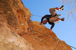
Unexpected by Fritzski   I'm not sure how many "Jacks Canyons" there are in Arizona, but this one sits on the high desert plateau country (6200'elev) as you emerge from the rim country pines south of Winslow. It is also known by the Hopi Indian name of Moenkopi, meaning "place of running water". I'm not sure how many "Jacks Canyons" there are in Arizona, but this one sits on the high desert plateau country (6200'elev) as you emerge from the rim country pines south of Winslow. It is also known by the Hopi Indian name of Moenkopi, meaning "place of running water".The spectacular scenery contained within the confines of this remote canyon seems out of place when compared to the spartan windswept landscape above. This canyon is a nationally renowned rock climbing area that draws many to climb its pristine limestone cliffs. Not to worry though, just a ten-minute walk in either direction will have you in almost certain solitude.
This narrow canyon was also known to be a travel route for the ancient Anasazi Indians, with relics and ruins from thousands of years ago having been found there. The campground at the top of the canyon is a delightful surprise being very neat, clean, and well kept, with a porta-john being funded by a N.Arizona climbing group. The camping spots are plentiful, well defined by neat little stone borders, and really quite serene being tucked in amongst a grove of gnarly-looking old junipers and other chaparral. The access trail down into the canyon is equally well kept and easy to follow on its steep and scenic ten-minute descent onto the canyon floor. It is easily located at the west end of the campground as you approach the canyon rim. This is obviously one of the few access points to the bottom without using ropes. Once at the bottom, it is obvious folks have spent some time arranging and maintaining the trail as it splits in various directions, but mainly to the left or right. The wall directly in front of you is the most popular climbing wall and is called "Casino Cliffs". Left is upstream (it actually seems like it should be the other way around!), and right is down with spring runoff flowing down from the Rim onto the high plateau. Although I did not have time to explore downstream, the topo would have you believe that upstream is where the canyon would come into its most spectacular. We were only able to go about two miles upstream on a very nice trail before nightfall forced us to turn back. It did indeed seem as things were getting better all the way. According to the lines on the topo map, it looked as though at about four miles upstream that the walls would grow to be about twice as high. It is definitely on my list to get in a good hike as far as I feel like going, along with some fantastic climbing the next time I go. Our trip this time was cut a day short due to a badly needed winter storm hitting us on the morning of the third day. Check out the Triplogs. Leave No Trace and +Add a Triplog after your hike to support this local community. | |||||||||||||||||||||||||||||||||||||||||||||||||||||||||||||||||||||||||||||||