Algonquin Trail #225 lies within the Castle Creek Wilderness and offers panoramic views of this area. The name was acquired from the Algonquin mine established in the early 1900s near Hell's Hole. The trail passes the mine location. It is located in the southern end of the Bradshaw Mountains, so-named for an early area miner.
The Bradshaw Mountain Range is walled by a dark metamorphic rock over 1.8 billion years old, intruded by younger igneous granites (tan in color). The igneous granites have eroded into the huge boulders typical of the area.
From the south trailhead at 6,800 feet, the trail begins a gradual descent. At mile 0.75, there is a campsite ideal for about 8 people and 4 horses. The trail from there continues downhill through Ponderosa pine, soon changing to chaparral. You can see two abandoned cabins from the trail; just beyond them is a campsite suitable for 4-5 people and 2 horses. The trail from here to Algonquin mine is not maintained, and hikers need to be particularly cautious. Algonquin Trail #225 intersects Horsethief Canyon Trail #30 in Horsethief Canyon, where there is a seasonal stream. The Algonquin mine at 4,600 feet is just 0.5 miles away. The trail continues within the canyon for 0.5 miles, past the headwaters of Poland Creek. It then begins the final ascent for 2.5 miles to the north trailhead on FR 259 up a steep switchback grade. This portion of the trail was initially used to haul ore on pack animals. As you approach the north trailhead, the broad vistas of the Verde Valley to the northeast and Pine Mountain to the east come into view. At 5 miles long, with a total elevation change of about 2,500 feet, this trail may be considered of moderate difficulty.
When hiking several trails on a single "hike", log it with a generic name that describes the hike. Then link the trails traveled, check out the example.
WARNING! Hiking and outdoor related sports can be dangerous. Be responsible and prepare for the trip. Study the area you are entering and plan accordingly. Dress for the current and unexpected weather changes. Take plenty of water. Never go alone. Make an itinerary with your plan(s), route(s), destination(s) and expected return time. Give your itinerary to trusted family and/or friends.
Only trailheads with six "amenities" have fees. Amenities are picnic tables, trash, toilet, parking, interpretive signing and security.
Directions
Road
FR / Dirt Road / Gravel - Car Okay
To hike Take 1-17 north out of Phoenix. Pass Black Canyon City up to the Bumble Bee Exit just after mile marker 248. Follow FR259 25.3 miles to the turnout on the left. The turnout is located between mile markers 24 & 25. Closer to 25. There's room for a half dozen cars. There is no visible trail signage. Look over the edge and you'll see the trail heading down. Trail signs are within the first quarter mile or so of the hike.
 Route Editor


 Algonquin Trail #225 lies within the Castle Creek Wilderness and offers panoramic views of this area. The name was acquired from the Algonquin mine established in the early 1900s near Hell's Hole. The trail passes the mine location. It is located in the southern end of the Bradshaw Mountains, so-named for an early area miner.
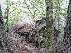


