Route Editor

| Guide | ♦ | 10 Triplogs | 0 Topics |
details | drive | no permit | forecast | route |
stats |
photos | triplogs | topics | location |
| 55 | 10 | 0 |
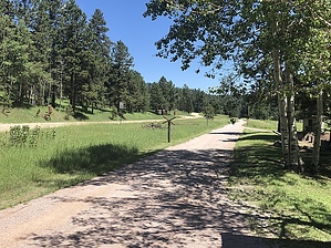
The trail is 109 miles long and contains more than 100 converted railroad bridges and 4 rock tunnels. The trail surface is primarily crushed limestone and gravel. There are 15 trailheads, all of which offer parking, self-sale trail pass stations, vault toilets, and tables. read in full @ sd.gov Wikipedia The main trail route extends 108.8 miles (175.1 km), from Edgemont to Deadwood, with approximately nine miles of additional branch trails, including a three-mile (5 km) paved link from Custer to the Custer State Park completed in 2007. Intermediate points along the route include the towns of Custer and Hill City, and a short branch provides access to the city of Lead.
The trail is maintained by the South Dakota Department of Game, Fish, and Parks. The first segment of the trail was opened in 1991, and the entire route was completed in 1998, and is the first rails to trails project in South Dakota. The trail is named after George S. Mickelson, the South Dakota governor who helped spearhead the project. Check out the Official Route and Triplogs. Leave No Trace and +Add a Triplog after your hike to support this local community. | |||||||||||||||||||||||||||||||||||||||||||||||||||||||||||||