Route Editor

| Guide | ♦ | 38 Triplogs | 1 Topic |
details | drive | permit | forecast | route |
stats |
photos | triplogs | topic | location |
| 96 | 38 | 1 |
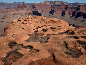
Black Diamond by Tim   Note: 21 mi RT is from the NPS. Tim logged 23.6 RT. GPS trace depicts 18.5 RT. Note: 21 mi RT is from the NPS. Tim logged 23.6 RT. GPS trace depicts 18.5 RT.Overview: This Grand Canyon trail is not maintained, but still easy to follow. However, expect a great deal of scree and exposed areas, especially in the steep sections of which there are two in particular. There are two ways to access the Boucher, ("Boo-shay"), Trail from the south rim. One is from The Dripping Springs Trailhead and the other more popular way is from Hermits Rest Trailhead as it has passenger vehicle access, (permit required), from the Grand Canyon Village. This description is from Hermits Rest. The total distance from Hermits Rest to Boucher Rapids was 11.8 miles per our GPS unit and it took us 8 1/2 hours, not including our 2-hour siesta at Boucher Creek.
Once you head over the saddle you begin the descent into a double black diamond. This is the steepest part of the trail as it heads down into a narrow canyon just west of Whites Butte. It is not necessary to lower packs anywhere on this part but it is steep throughout. With a pack on your back, the knees can take a beating. A HAZ member, Desert Girl, recommended investing in a pair of hiking poles which paid for themselves twice over on this trip. After coming off of this double black diamond you begin a more gradual westward descent to the intersection with the Tonto Trail. From this intersection, you continue to head west into Boucher Creek. At Boucher Creek, you will find a wonderful stream of cool running water. Some enterprising hikers from the past have constructed several small dams which create several pools under a cottonwood tree that you can filter water from and "wallow" in to cool off. This was a great stop for a rest and took approximately 10 miles in and took 7 1/2 hours to get to. We elected to take an extended break here before heading the rest of the way down the creek to the river. The remaining 1.8 miles took less than an hour and simply follows the creek bed the entire way. We found it easier to walk straight down the creek and accept wet feet rather than trying to follow the side of the creek amongst the scrub brush. At the intersection of Boucher Creek and Topaz Canyon, you will see a large pile of cairns on the bank above you to the left. This is where the Tonto Trail continues west. You continue to head to your right, (ie: south), down the creek. At this point, the creek winds through some spectacular slot canyons until it finally emerges on the beach at Boucher Rapids. There are numerous campsites on this sandy beach. It's the best campsite I've ever had. The Colorado River is significantly colder than Boucher Creek but braving a dip is a well-deserved reward after a hard day's work.
Check out the Official Route and Triplogs. Note This is a difficult hike. It would be insane to attempt this entire hike without prior experience hiking. Leave No Trace and +Add a Triplog after your hike to support this local community. | ||||||||||||||||||||||||||||||||||||||||||||||||||||||||||||||||||||||||||||||||||||||||||||||||||||||||||||||||||||||||||||||||||||||||||||||||||||||||||||||||||||||||||||||||||||||||||||||||||||||||||