 Route Editor

| Guide | ♦ | 1 Triplog | 0 Topics |
details | drive | permit | forecast | route |
stats |
photos | triplog | topics | location |
| 30 | 1 | 0 |
rollercoaster ridge by LindaAnn Hike The trail starts at a parking area at the northwest corner of Johnson Saddle. The climb starts immediately from the north end of the parking area. You will quickly notice this is a popular trail with the dirt bike crowd, as deep ruts have been formed down the center of the trail. There's also a lot of loose rock on the trail in places. Sometimes, trail damage from the dirt bikes is annoying, but on the flip side, the riders do a lot of brush clearing on the trails in North Idaho. Without their clearing, a lot of trails would quickly become severely overgrown and nearly impossible to follow.
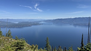
At the saddle on the east side of Green Monarch Mountain, the climb begins again, steep at times. About a quarter-mile from the summit of Green Monarch, the best views of the trail appear. There are some good breaks in the trees, and you can clearly see Lake Pend Oreille from Clark Fork all the way over to Sandpoint. The Cabinet Mountains are visible to the northeast, and the Selkirks are visible to the northwest. Use caution at the cliff edge, you are standing at 5000' and the water straight below you is at 2060', quite a drop. If you were only interested in this trail for these views, you might as well turn around here or at the summit, a short distance away. After the summit of Green Monarch, the trail drops steeply off the west side of the peak, down to the saddle between Green Monarch and Schafer Peak. Trail 69 ends at that saddle, where there is a junction with Schafer Peak Trail 68 and Tepee Gulch Trail 105, but there is no signage indicating that fact. If you've reached that junction, you can either turn around or continue on one of the other trails for a longer hike. Check out the Official Route and Triplog. Leave No Trace and +Add a Triplog after your hike to support this local community. One-Way Notice This hike is listed as One-Way. When hiking several trails on a single "hike", log it with a generic name that describes the hike. Then link the trails traveled, check out the example. | |||||||||||||||||||||||||||||||||||||||||||||||||||||||||||||||||||||||||||||||||||||


