This trip starts from the horse-trailer parking lot where the fee boxes are located off FS78.
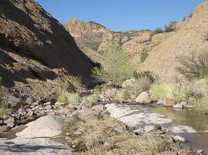
Start walking east along the road to the trailhead. About 0.1 miles down the road there's a pull-off with a closed gate. Crawl through the fence and follow the road about 0.3 miles to an old corral and windmill. There are lots of trails crisscrossing Firstwater Creek in this area, pick one and find the creek bed. Once in the creek start going north into the slick rock canyon. Once you're in the canyon follow it for about 0.25 miles. At this point the canyon will split; follow the canyon east, not north. Shortly after the split, the canyon feeds into another canyon. To the north, the canyon continues, to the south it kind of peters out and gives a great view of the east side of Superstition Mountain. You want to go north. About halfway down this stretch of canyon, right before it starts bearing east, there is a nice copse of trees with a few campsites and a well-used cave. There's a big rock in the middle of the creek with a giant arrow pointing to the east, I think this is someone's marker for the campsite, at least I couldn't find anything else that it might be marking. The area would make a nice camping spot, especially with all the insects and other animals that frequent the spring. Just a short way further there's another stand of trees, larger and greener than the previous one. This is when you'll know you're near the spring. The canyon runs east and west with the spring on the south side of the canyon. On the north is a nice shady spot that's been well cleared by past campers. The spring is not visible from the creek bed but it's not difficult to find, just look for a path out of the creek on the south side of the canyon. There is a pipe that comes out of the cliff wall and a defunct collector just below it.
There is no water at the trailhead and usually none in the creek however there are sometimes stagnant pools in the canyon rock, and there is the spring, which is said to have water year-round, but I wouldn't count on it. Pack in all the water you need. Remember if you camp here that the desert animals rely on the spring for their water. Please don't camp near it if at all possible. Even camping near the spring disrupts the animal's natural habits and can be extremely detrimental to their health. Besides with all the mosquitoes and bees flying around who would want to camp near it anyway?
Gate Policy: If a gate is closed upon arrival, leave it closed after you go through. If it is open, leave it open. Leaving a closed gate open may put cattle in danger. Closing an open gate may cut them off from water. Please be respectful, leave gates as found. The exception is signage on the gate directing you otherwise.
WARNING! Hiking and outdoor related sports can be dangerous. Be responsible and prepare for the trip. Study the area you are entering and plan accordingly. Dress for the current and unexpected weather changes. Take plenty of water. Never go alone. Make an itinerary with your plan(s), route(s), destination(s) and expected return time. Give your itinerary to trusted family and/or friends.
Permit $$
None
Directions
Road
FR / Dirt Road / Gravel - Car Okay
To Horse Lot Trailhead From Mesa follow Highway 60 East to Idaho Road. Turn North onto Idaho Road which is SR88 and follow North 2.2 miles. SR88 bends right just past Scenic St. and Idaho continues North. Be sure to go right and stay on SR88. Follow SR88 5.2 miles to the signed turnoff for First Water Trailhead, this is FR-78. Turn right on to FR-78 and follow 2.1 miles to the huge parking area on the left surrounded by horse rails.
From PHX (I-10 & AZ-51) 42.6 mi - about 57 mins From TUC (Jct 1-10 & Grant) 136 mi - about 2 hours 15 mins From FLG (Jct I-17 & I-40) 187 mi - about 3 hours 1 min
 Route Editor

 Two other loop options