Route Editor

| Guide | ♦ | 42 Triplogs | 1 Topic |
details | drive | no permit | forecast | 🔥 route |
stats |
photos | triplogs | topic | location |
| 409 | 42 | 1 |
Canyons are inherently risky. Flash floods occur without notice on sunny days. Technical skills & surrounding topography knowledge required yet does not eliminate risk.
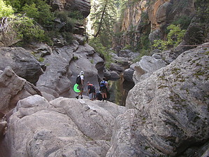
High elevation canyon by J&SHike  Willow Valley sits at an elevation of 6700'. With its narrows, mandatory swims, boulder hopping, scrambling, and some route-finding, this is an excellent place for people to get a taste of canyoneering in a great day hike. Willow Valley sits at an elevation of 6700'. With its narrows, mandatory swims, boulder hopping, scrambling, and some route-finding, this is an excellent place for people to get a taste of canyoneering in a great day hike.My buddy and I did this hike on Labor Day. Neither of us had been here before, so we set out early to try and find the canyon. Follow the directions given below. Park your car at the tank (which will be on your right) or park as we did under the big ponderosa on the other side of the road opposite the tank.
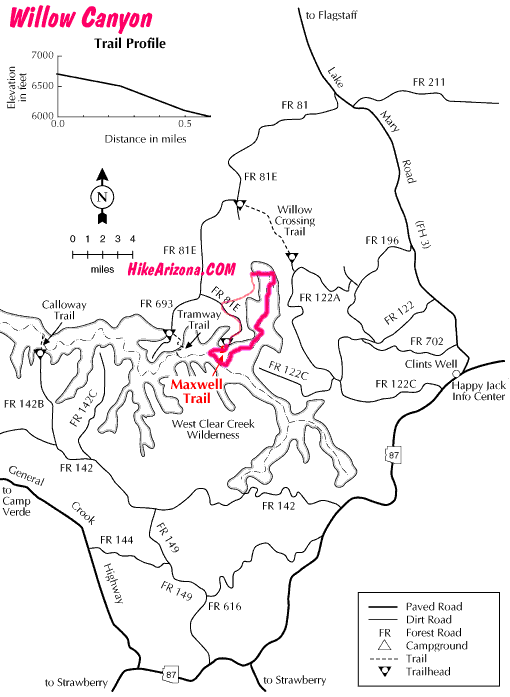
Once in Willow Valley, it's a short way before you come to three to four swims, the first two you can climb around, which are described in Williams' book "Canyoneering Arizona" as 5.1 climbs. So just swim for it. It's deep water in all of the pools. The first pool is an easy swim and a flat rock to start your swim off of too. The second pool is a little trickier; you scramble down onto the wet rock and go right in. The third pool is a mandatory swim. This one is tricky. Once you scramble down, it gets real narrow, and the rock sort of goes straight down into the water. There is a ledge you can slide over and onto and start from there or just go feet first into the water. We decided on the ledge. You scramble over a rock and slide down onto the ledge, which is slick and underwater. If you fall to your right, you fall into a 5-foot pool. If you fall to your left (which is the swimming path), then you fall into deep water, so be careful; it's only about 4 feet wide for about 10 feet or so. The last pool Williams' book said it was a wade, but it was way deeper than any wade. We found a way around this one on creek right up a rock slope, over, and kind of spider man your way around a narrow ledge then jump from there onto the beach. After the swims, which were cold water, you boulder hop and bushwack your way downstream. It widens up a bit, and flowing water starts. A trail starts to form here and there as well. Campsites appear on both sides of the creek after a while, and of course, stupid people trash. For heaven's sake, people, if you don't want to eat your bagel, crackers, or banana, take it with you; don't leave it for the animals as someone did down here. It makes the animals less scared of you and more apt to go through your pack at night. Yeah, and there are bears and mountain lions around here too... You'll finally come to the origin of West Clear Creek. It's easy to recognize as another stream (Clover Creek) joins Willow Valley forming West Clear Creek. It's a wide-open area with cobblestones everywhere. About a half-mile more, you come to the Maxwell Trail #37. It's not marked, so pay attention, and the trail will be on creek right going up and away just before the canyon makes a sharp left. The Maxwell trail is 0.6 miles up to the trailhead, and your shuttle vehicle, if you left one, or mountain bike or road walking (3 miles) back to your car at the start of the hike. This is a great hike to get your feet wet literally and figuratively to see if you are up to canyoneering. Just make sure it's not going to rain, especially in the narrow parts. It rained on us with a thunderstorm in the afternoon and lasted the whole way home. Not cool when lightning bolts and heavy rains are all around you. Outside temperatures should be around 85 to 95 degrees due to the cold waters you'll be swimming in or wading in. It was 86 degrees when we went, and I would have preferred 90 degrees or so. Have fun, pick up after yourselves and those "other" non-appreciating people of the canyon. We saw no one on this entire hike, just what they left behind, no trash up in the narrows down until the campsites appeared. Gate Policy: If a gate is closed upon arrival, leave it closed after you go through. If it is open, leave it open. Leaving a closed gate open may put cattle in danger. Closing an open gate may cut them off from water. Please be respectful, leave gates as found. The exception is signage on the gate directing you otherwise.
Check out the Official Route and Triplogs. Leave No Trace and +Add a Triplog after your canyon trip to support this local community. | ||||||||||||||||||||||||||||||||||||||||||||||||||||||||||||||||||||||||||||||||||||||||||||||||||||||||||||||||||||||||||||||||||||||||||||||||||||||||||||||||||||||||||||||||||||||||||||||||||||||||||||||||||||||||||||