username
X
password
register
for free!
help
 This is likely a great time to hike this trail!  Check out "Preferred" months below, keep in mind this is an estimate.
 

Big Creek Trail #11, MT

Guide 1 Triplog  0 Topics
  5 of 5  
Fav
Wish
0
details
drive
no permit
forecast
route  
stats
photos
triplog
topics
location
12 1 0
Statistics
tap row or icons for details
Difficulty 4.5 of 5
Distance One Way 12.55 miles
Trailhead Elevation 3,998 feet
Elevation Gain 3,217 feet
Accumulated Gain 3,698 feet
Kokopelli Seeds 24.87
unreported if dogs are allowed
editedit > ops > dogs to adjust
feature photo
Photos Viewed All MineFollowing
Will recalculate on button tap!
12  2018-07-12 FOTG
Author
author avatar Guides 16,843
Routes 17,472
Photos 24
Trips 1 map ( 6 miles )
Age 28 Male Gender
Location HAZ, TrailDEX
Associated Areas
list map done
Western Region
Historical Weather
Trailhead Forecast
Radar Map
Expand Map
Preferred May, Sep, Jun, Apr
Sun  6:02am - 7:08pm
Official Route & 1 Rt
 
0 Alternative


remove free decal offer

 Likely In-Season!
Guide Needed
Publish Full Detail Guide


Use +Add above to share photos and triplogs
Overview
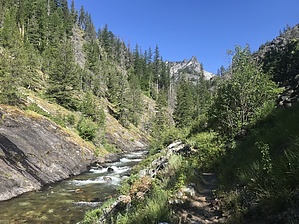
The Big Creek trail is 14.1 miles long. It begins at Road #738 and ends at Packbox Pass. Continue on for a badass loop through Idaho.


    Check out the Official Route and Triplog.

    Note
    This is a more difficult hike. It would be unwise to attempt this without prior experience hiking.
    Leave No Trace and +Add a Triplog after your hike to support this local community.

    One-Way Notice
    This hike is listed as One-Way.

    When hiking several trails on a single "hike", log it with a generic name that describes the hike. Then link the trails traveled, check out the example.
    WARNING! Hiking and outdoor related sports can be dangerous. Be responsible and prepare for the trip. Study the area you are entering and plan accordingly. Dress for the current and unexpected weather changes. Take plenty of water. Never go alone. Make an itinerary with your plan(s), route(s), destination(s) and expected return time. Give your itinerary to trusted family and/or friends.

     Permit $$
    no fees or permits reported

    if incorrect tell us about it


     Directions
    or
     Road


    To hike
    page created by HAZ_Hikebot on Mar 09 2010 5:16 pm
     90+° 8am - 6pm kills
    helpcorrectionissue

    end of page marker