 Route Editor

| Guide | ♦ | 124 Triplogs | 19 Topics |
details | drive | no permit | forecast | 🔥 route |
stats |
photos | triplogs | topics | location |
| 943 | 124 | 19 |
Gems few aquire by HAZ_Hikebot   2020 Legal Notice 2020 Legal NoticeThe legal non-technical route is 1-2-3-4-3-2-1 as described in MLDV below. Never go on private property without permission. Summary space is reserved. Triplogs tell the story well.
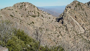
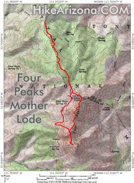
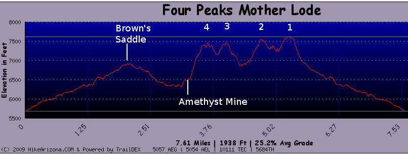
Extreme outing, the majority of the trek is off-trail scrambling to class four ( class three if you choose wisely ) that requires nerves of steel. Trail data is likely inaccurate. It's unlikely the same route will be taken twice until you get to know the peaks on a personal basis. For clarification, peaks are noted as North to South: Brown's Peak 7657(1) Brother Peak 7642(2) Sister Peak 7572(3) Amethyst Peak 7524(4) The name "Four Peaks Mother Lode" was dubbed in 2003 on a 4-3-2-1 approach. It crosses private property, which is no longer being granted. Stay legal with the 1-2-3-4-3-2-1 approach. The term MLDV - "Mother Lode Dos Veces" surfaced in 2009. Meaning over the peaks and back (7 summits) 1-2-3-4-3-2-1. View this graph of the route going backwards starting at (4).
Check out the Official Route and Triplogs. Note This is a difficult hike. Arrive fit and prepared or this could get ugly. Leave No Trace and +Add a Triplog after your hike to support this local community. | |||||||||||||||||||||||||||||||||||||||||||||||||||||||||||||||||||||||||||||||||||||||||||||||||||||||||||||||||||||||||||||||||||||||||||||||||||||||||||||||||||||||||||||||||||||||||||||||||||||||||||||||||||||||||||||


