|
tap row or icons for details
|
| Difficulty |
|
3 of 5 |
| Route Finding |
|
1 of 5 |
| Distance Round Trip |
|
8.75 miles |
| Trailhead Elevation |
|
3,550 feet |
| Elevation Gain |
|
3,392 feet |
| Avg Time Round Trip |
|
5 hours |
| Kokopelli Seeds |
|
25.71 |
| Interest Historic, Perennial Waterfall, Perennial Creek & Peak | | Backpack Yes | |
| | |
|
|
25 |
2022-10-09 | Lucyan |
|
|
23 |
2020-09-05 | wanderingtrails |
|
|
115 |
2020-08-09 | Lucyan |
|
| |
|
|
|
list |
map |
done |
North Cascades Region |
| | |
|
| |
|
|
Historical Weather |
| Trailhead Forecast | | |
|
 |
|
|
| Preferred Jun, Jul, Aug, Sep → 8 AM |
| |
|
|
| | |
| |
Named Locations Coordinate Links
| |
|
| help future hikers |
| post a gps route now |
| | |
| |
|
|
 Overview Overview
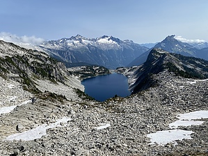
Hidden Lake Lookout is a beautiful hike with a steady elevation gain over a very well maintained trail. The road to the trailhead is very rocky and has huge potholes, high clearance recommended. Hike
The trail starts in Mt. Baker National Forest, but the lake and fire lookout are part of North Cascades National Park. The hike starts in an old-growth forest with a pleasant ascent through the pines. The trail then transitions through flower fields and tall shrubs until it reaches a ridgeline where it evens out for a bit. Trail then moved into alpine terrain with a few year-round snow crossings. Finally, you earn a saddle with a great view of Hidden Lake. Continue past the saddle and up to the fire lookout. From the saddle to the lookout it’s a scramble over a massive boulder field. The lookout at the top can be camped in, first come, first served. |
 Route Editor