Route Editor

| Guide | ♦ | 32 Triplogs | 0 Topics |
details | drive | no permit | forecast | 🔥 route |
stats |
photos | triplogs | topics | location |
| 518 | 32 | 0 |
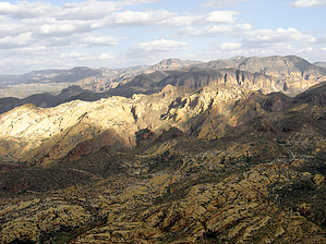
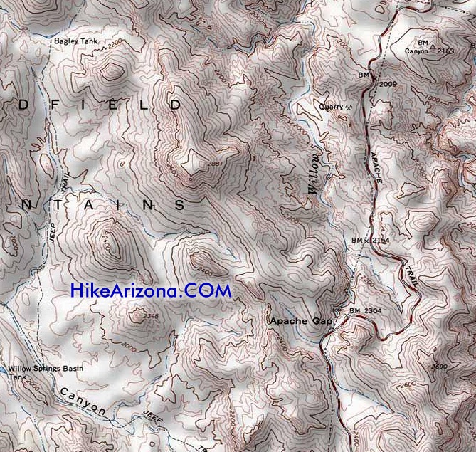
The Javelina Inn by rowjimmy76  Have you ever wondered what secrets the terrain holds west of the Apache Trail? Are you looking for a short hike with an outstanding 360' view that you will almost certainly have to yourself? Do you enjoy off-trail routes that are easy to negotiate? If you answered yes to any of these, then a sojourn to the top of peak 2881 in the Goldfield Mountains, just west of Apache Gap, might be in order. Have you ever wondered what secrets the terrain holds west of the Apache Trail? Are you looking for a short hike with an outstanding 360' view that you will almost certainly have to yourself? Do you enjoy off-trail routes that are easy to negotiate? If you answered yes to any of these, then a sojourn to the top of peak 2881 in the Goldfield Mountains, just west of Apache Gap, might be in order.You can start this hike from several turnouts along AZ 88. I would recommend not using the one I did and opt for either the parking area at Apache Gap or the next pull out after that heading towards Canyon Lake. Either should make for a relatively straightforward hike up peak 2881. I knew I would be doing this peak as a part of a loop hike, so I parked about a mile before Apache Gap to follow the jeep trail south from Bagley Tank back to the car.
Next time, I will head east off the saddle between peak 2881 and point 2631. On this trip, I headed west from the saddle north of peak 2881 towards Bagley Tank. Before I reached the saddle, menacing animal noises in the bushes to my right startled me. No sooner did I assure myself it was nothing, a pack of javelinas darted out of the bushes. If their growls were any indication, they were as displeased with our encounter as I was. I continued walking away from them, and another bush yielded several more javelinas. By now, I was pretty shaken, hiking alone, but it passed soon enough. Once at Bagley Tank, far removed from the javelinas and the pretty ridgeline, I followed a jeep trail through scenery of more modest acclaim. When the jeep trail makes a southerly turn near the "L" in "TRAIL" (on the 7.5' map) and crosses the wash, I left the jeep path and bushwacked east to the power lines next to AZ 88. At this point, I followed the terrain north to where I started, only slightly scratched up from the 6-mile loop. Overall, I think that peak 2881 is well worth your time. However, I would not highly recommend the loop that I did. A much better loop would be to head east off the saddle north of peak 2881 down the unnamed wash. Then, head south down Willow Creek back to your vehicle. Of course, peak 2881 can be enjoyed by itself as well. Not a bad Wednesday hike at all...
Check out the Official Route and Triplogs. Leave No Trace and +Add a Triplog after your hike to support this local community. | |||||||||||||||||||||||||||||||||||||||||||||||||||||||||||||||||||||||||||||||||||||||||||||||||||||||||||||||||||||||||||||||||||||||||||||||||||||||||||||||||||||||||||||||||||||||||||||||||