Route Editor

| Guide | ♦ | 42 Triplogs | 0 Topics |
details | drive | no permit | forecast | 🔥 route |
stats |
photos | triplogs | topics | location |
| 414 | 42 | 0 |
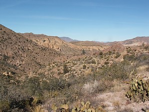
Interior View of Superstitions by Tim  This hike is described in great detail in Carlson's "Hiker's Guide to the Superstition Wilderness" under trip #41. This hike is described in great detail in Carlson's "Hiker's Guide to the Superstition Wilderness" under trip #41.This hike started off being an 8.2-mile loop but quickly expanded to 14.4 miles when we saw FSR 213. While the four of us, (Carolyn, Paul, and Jim), were in a 4x4 Tahoe, there was no way it was getting up that road without leaving some key automotive components behind. I don't think a Hummer could get up that road. You'd have to have one seriously jacked-up vehicle to clear the rocks at the start of this "road". Walking the road added 3.1 miles to each end of the hike and took an hour each way, but was quite pretty.
Coming down from the saddle one heads across Horse Basin until intersecting a wash at the bottom. This is where the fun starts. From this junction, one backtracks sharply to your right towards a low point on the ridge. Now in Carlson's book, they recommend heading up the wash to the top of the ridge before heading west to the saddle as this route has less cat claw, but I'm not so sure. We ground it out up the wash which in spots was very overgrown. (NOTE: A great strategy for bushwhacking is to send a big Irishman, (that would be Jimmy), into the thickets first to widen the path.) Once we got as far as the "H" in "Horse Camp" on the topo, we had had enough of the creek and elected to head due west up the ridge. This proved to be much easier going. Once you reach the saddle you can look down into the flat plain between Horse Ridge and Tortilla Mountain where Peters Trail lies. After heading down this ridge and across yet another wash we stumbled across Peters Trail for the trip back to Tortilla Well. This is the prettiest part of the hike as the trail winds down a narrow canyon to Kane and Indian Spring. The views on the way down are spectacular and I recommend doing the loop in a clockwise fashion for this reason. After passing Indian Spring, (dry), you cross Tortilla Creek several times before exiting a narrow slot canyon just before the trailhead. The actual 8.2-mile loop from trailhead to trailhead took us 3 1/2 hours with just a brief break for lunch. Overall, the trip was 14.4 miles and 5 1/2 hours to and from the Apache Trail. Gate Policy: If a gate is closed upon arrival, leave it closed after you go through. If it is open, leave it open. Leaving a closed gate open may put cattle in danger. Closing an open gate may cut them off from water. Please be respectful, leave gates as found. The exception is signage on the gate directing you otherwise. Check out the Official Route and Triplogs. Leave No Trace and +Add a Triplog after your hike to support this local community. | ||||||||||||||||||||||||||||||||||||||||||||||||||||||||||||||||||||||||||||||||||||||||||||||||||||||||||||||||||||||||||||||||||||||||||||||||||||||||||||||||||||||||||||||||||||||||||||||||||||||||||||||||