 Route Editor

| Guide | ♦ | 7 Triplogs | 0 Topics |
details | drive | no permit | forecast | route |
stats |
photos | triplogs | topics | location |
| 34 | 7 | 0 |
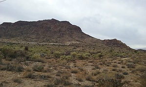
Bull King Awesome Views by johnner   Note NoteThe current Official Route is from the SW. The guide below is directly south. The south approach is shorter distance-wise yet sounds like a higher pucker factor. HAZ_Hikebot will update as more information becomes available. Prologue Bull Mountain is the prominent, flat-topped massif about 3 miles North of Kingman, AZ. On many past visits, I thought of climbing it. This time, I would not let it go unclimbed. I studied many different possible routes. All sides of it are steep, and a clifflike ribbon of broken rock bands the mountain. Upon closer examination, the whole mountain seems like a colossal rockpile.
Hike I opted for the Southside, which has the shortest approach but gets real steep real fast. I went down the old mining road about a mile past the large mine as seen from the city, parked the truck, and headed up. I decided to stay on a ridge to avoid vegetation. The going was easy until about halfway up where the ribbon of rock begins. Here I got into some class 4 climbing, but it was not as bad as it looked from below. Just a giant staircase to the top of "the Bull". There are many loose rocks, so if you climb this one, be careful to test before you trust. After about 25 minutes of the "staircase", I found myself on a gentle but long slope upward to the top. I headed Northwest towards the shoulders of "the Bull", which is the summit. The views of Kingman were great. This mountain is so steep that you feel like you are in an airplane, high above the city. Coming down, I decided to try a gulley next to the ridge that I took up. It was less steep, the vegetation not too bad, and the footing is better than the ridge - less scree. One section was probably a 5.6 where I had to downclimb for 10 or 12 feet. Bull Mountain is another "out there" kind of climb, where there are no trails, and few people go because it is a little on the difficult side. It's not that bad, though. Just choose your route carefully, and watch for loose rock. Check out the Official Route and Triplogs. Note This is a moderately difficult hike. Leave No Trace and +Add a Triplog after your hike to support this local community. One-Way Notice This hike is listed as One-Way. When hiking several trails on a single "hike", log it with a generic name that describes the hike. Then link the trails traveled, check out the example. | ||||||||||||||||||||||||||||||||||||||||||||||||||||||||||||||||||||||||||||||||||


