 Route Editor

| Guide | ♦ | 9 Triplogs | 0 Topics |
details | drive | permit | forecast | route |
stats |
photo | triplogs | topics | location |
| 1 | 9 | 0 |
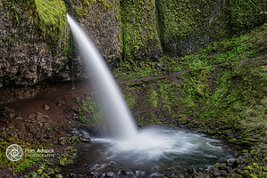
 There are four waterfalls in Oneonta Gorge. The Lower Falls, which drains into a narrow slot canyon, is not visible from the trail. Middle Falls is visible from the trail. The upper falls are about 1 mile upstream from the middle falls and require climbing down a canyon wall to view. After approximately 1.7 miles you will reach Triple Falls, which can be seen from a vantage point on the upper trails in the canyon. Hiking to Triple falls would make a good day hike and is just over 4 miles roundtrip.
This trail is within Mark O Hatfield Wilderness from Horsetail Falls Trail #438 to Multnomah Creek Way #444, which means bikes are prohibited and additional wilderness restrictions apply. Mountain Biking is only between the summit of Larch Mountain until the wilderness begins at Multnomah Creek Way Trail #444. Oneonta Trail ends at Larch Mountain Road 0.3 miles south of Larch Mountain Picnic Area. For one of the most far-ranging views in the Columbia River Gorge, continue from Larch Mountain parking for another 0.3 miles along a trail that leads to Sherrard Point. Backpacking This hike begins at Oneonta West Trailhead, and connects with a number of other trails for short or long day hikes. Consult a good up-to-date map when planning your trip and bring the 10 Hiking Essentials. Day Hiking This hike begins at Oneonta West Trailhead, and connects with a number of other trails for short or long day hikes. Combining this trail with Horsetail Falls is a popular loop hike. Hiking to Triple falls makes a good day hike, at just over 4 miles roundtrip. If you plan to explore longer hikes by connecting to other trails, please bring the 10 essentials. Note: Several guidebooks and blogs mistakenly refer to the creek at Oneonta Gorge as "Oneonta Trail"; however, Oneonta Gorge is NOT an official trail. Check out the Official Route and Triplogs. Leave No Trace and +Add a Triplog after your hike to support this local community. One-Way Notice This hike is listed as One-Way. When hiking several trails on a single "hike", log it with a generic name that describes the hike. Then link the trails traveled, check out the example. | ||||||||||||||||||||||||||||||||||||||||||||||||||||||||||||||||||||||||||||||||||||||||||||||||||||||||||||||||||||||||||||||||||||||||||||||||||||||||||||||||||


