 Route Editor

| Guide | ♦ | 59 Triplogs | 2 Topics |
details | drive | permit | forecast | 🔥 route |
stats |
photos | triplogs | topics | location |
| 772 | 59 | 2 |
Rewarded with Ruins by Al_HikesAZ  Overview OverviewRuins of an ancient Verde Hohokam pueblo and fort reward you for this arduous hike. Skull Mesa is the large, flat mountain north of Cave Creek. It is in the middle of the Cave Creek / Seven Springs trail system of the Tonto National Forest - approximately 31 miles of interconnected trails. This description is for the hike from the Spur Cross Conservation Area at the southwest up to the mesa and on to the ruins. Skull Mesa can also be reached from the northeast, starting from the Seven Springs campground. This Spur Cross route is steeper but slightly shorter. The drive to the Spur Cross trailhead will be quicker and more comfortable for many people than the drive to the Seven Springs trailhead. The Seven Springs route will be described in a separate trail description. In the Falcon book, Hiking Ruins Seldom Seen, Dave Wilson describes the history and archeology of this site. He also describes proper etiquette when visiting ancient ruins. The basics of his rules of etiquette are: 1) Do not lean, climb or walk on walls or roofs 2) Do not pick up an artifact then place it somewhere else 3) Do not touch rock art 4) Do not chalk rock art 5) Do not take pottery 6) Do not build fires
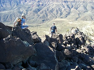
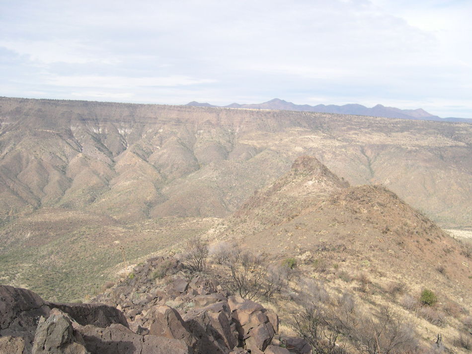
From the Spur Cross trailhead, start north on the old dirt road. You will make your first crossing of Cave Creek on well-placed boulders and then enter the Tonto National Forest. You will cross Cave Creek 3 more times and end up on the east side. The crossings are normally shallow if water is running, but you will need to hop across on some boulders if you want to stay dry. At 2.2 miles, you reach the trailhead for Cave Creek Trail #4. (elevation 2,394 feet). Continue. You will reach Trail 247 in about 200 yards at 2.33 miles 2,425 feet elevation. Turn right. Cross a small creek bed and begin the up & down through the hills, talus & scree. You will climb 250 feet in about 1/3 of a mile. You reach Cottonwood Springs at 3.35 miles. This spring appears to have perennial water. Continue past the lava flow and the Trail 247 marker until you hit a gate and a junction at 5 miles 3,180 feet elevation. Cottonwood Trail 247 continues, but you will turn left on Trail #248. The fun begins with a series of steep switchbacks. You reach the mesa at 6 miles 4,250 feet elevation (33 55'46"N, 111 55'21"W). Follow the well-cairned trail for eight or ten cairns to the east until you get past the rock outcropping and onto the main part of the mesa. If you head due north on reaching the mesa, you will eventually have to climb over the rocks, and they get higher as you go out on the mesa. Up until now, the trail has been well-marked and easy to follow. Now you will leave the trail and bushwhack north across the mesa. The ruins are just off the northwest edge of the mesa. Your goal now is the right edge of the mountain range in the distance. During the summer, I have encountered rattlesnakes in this area, so proceed with appropriate caution. The Cave Creek Complex fire in 2005 charred the mesa. At 6.7 miles (33 55'87"N, 111 55'22"W), you will find an area of black boulders and petroglyphs. Now head northwest to the edge of the mesa. Your goal is the third peak from the left of the mountain range in the distance (see photo). At 7.8 miles, you will leave the mesa and descend into the first small saddle. Here you will start clambering over the boulders. You will work your way down, then back up through another saddle and then down and across the last saddle. Here you will find the ruins of the pueblo. Continue through the saddle, past the pueblo, and up a small hill to the fort's ruins at 8.3 miles (33 56'56"N, 111 55'54"W). Leave anything you find for others to enjoy. Read the Rules for Ruins in the overview above. Enjoy the spectacular views and head back to the trailhead. There are ruins on Elephant Mountain to the southwest and St. Clair mountain to the east that "should" be visible from here. I could not find them through my binoculars, but I wasn't exactly sure where to look or what to seek. Gate Policy: If a gate is closed upon arrival, leave it closed after you go through. If it is open, leave it open. Leaving a closed gate open may put cattle in danger. Closing an open gate may cut them off from water. Please be respectful, leave gates as found. The exception is signage on the gate directing you otherwise. Check out the Official Route and Triplogs. Note This is a moderately difficult hike. Leave No Trace and +Add a Triplog after your hike to support this local community. | |||||||||||||||||||||||||||||||||||||||||||||||||||||||||||||||||||||||||||||||||||||||||||||||||||||||||||||||||||||||||||||||||||||||||||||||||||||||||||||||||||||||||||||||||||||||||||||||||||||


