Route Editor

| Guide | ♦ | 18 Triplogs | 0 Topics |
details | drive | no permit | forecast | route |
stats |
photos | triplogs | topics | location |
| 23 | 18 | 0 |
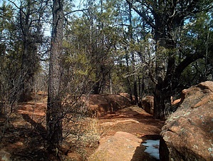
  Note NoteThis hike is on private property. The owner appears to be allowing access to the most popular segment as an out-n-back hike. Please be respectful and obey official signage. Overview This trail is very popular and is visited annually by thousands of people from around the world. The trail follows relatively level terrain to the very edge of the Mogollon Rim. There are excellent scenic vistas along the trail.
A hike along this self-guided interpretive trail gives visitors a great appreciation of the characteristics of the Mogollon Rim and its uniqueness as the dividing line between the Colorado Plateau and the Gila-Salt River watersheds. It is likely more kinds of trees, bushes, and shrubs can be seen growing side-by-side along this trail than any other area on the district. Pacific willow and Bebb's willow, together with a wide variety of water plants and sedges can be found growing along an irrigation ditch which has an interesting history relating to pioneers in the area. Notes The Mogollon Rim was named for Don Juan Ignacio Flores Mogollon, who was the Governor of the Province of New Mexico between 1712 and 1715. This self-guided interpretive trail is a one-mile loop that takes about an hour to complete. The first 1/2 mile is paved and universally accessible. Access The trail is located along State Highway 260 between Show Low and Lakeside, approximately 3 miles northwest of the district office.
Check out the Official Route and Triplogs. Leave No Trace and +Add a Triplog after your hike to support this local community. | |||||||||||||||||||||||||||||||||||||||||||||||||||||||||||||||||||||||||||||||