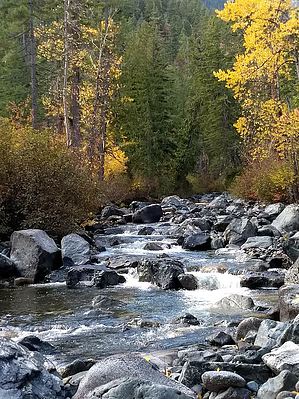
Ingalls Creek Trail is 15.5 miles long, gains 4400 feet of elevation, and is used by hikers and stock users. The trail begins at Ingalls Creek Trailhead and climbs steadily through the forest alongside Ingalls Creek. Several trails have junctions with Ingalls Creek Trail as it heads east up the valley: Falls Creek Trail #1216, then Cascade Creek Trail #1217, followed by Hardscrabble Creek Trail #1219, Fourth Creek Trail #1218, Turnpike Creek Trail #1391, and Longs Pass Trail #1229. The trail between the trailhead and the junction with Longs Pass Trail #1229 gains elevation slowly, is mostly below tree-line, and is easy to follow, but after that junction it climbs more steeply, cuts across open, alpine meadows, and becomes brushier in places. This last section of the trail is 3.3 miles long and ends at Stuart Pass, where the trail turns into Jack Creek Trail #1558. There are many designated campsites for both hikers and stock along the length of the trail, and plenty of accessible water. The trail can be very brushy in sections. Additionally, there is no horse feed below Fourth Creek and limited feed above.
When hiking several trails on a single "hike", log it with a generic name that describes the hike. Then link the trails traveled, check out the example.
WARNING! Hiking and outdoor related sports can be dangerous. Be responsible and prepare for the trip. Study the area you are entering and plan accordingly. Dress for the current and unexpected weather changes. Take plenty of water. Never go alone. Make an itinerary with your plan(s), route(s), destination(s) and expected return time. Give your itinerary to trusted family and/or friends.
To hike From Wenatchee, WA take US-2 W/US-97 S for 13.9 mi. Then take the exit for U.S. 97 and follow U.S. 97 S for 7 miles. Then turn right onto Ingalls Creek Road and follow for about a mile to the trailhead.
page created by HAZ_Hikebot on Mar 09 2010 5:31 pm
 Route Editor


