Route Editor

| Guide | ♦ | 46 Triplogs | 2 Topics |
details | drive | no permit | forecast | map |
stats |
photos | triplogs | topics | location |
| 439 | 46 | 2 |
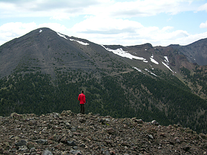
A solitude hike bagging 2 peaks by MtnGeek   Off limits? Off limits?Senecio protection area [ map, pdf ] is off limits off-trail unless skiing or snowshoeing on covered snow to protect the San Francisco Peaks groundsel. This hike is not in the protection area. Things may change. Never cross into posted restricted areas. Check with land management before entering. Fremont Peak: 11,969 feet Doyle Peak: 11,460 feet
The second is from Locket Meadow. This is your shortest approach. From the Inner Basin Trailhead take it till you get into the Inner Basin. Stay on the trail till you get considerably close to Fremont Peak. Get off the trail and hike up the treeless rocky area till you intercept the Weatherford Trail. Take a left till you get to the Saddle. These two peaks offer very different views of Flagstaff and the surrounding areas. Fremont gives a better view out of these two peaks. On this hike, since they sit right next to each other it only makes sense to hike them both. They can also be done in conjunction with doing Humphreys Peak to make for a longer hike. From the saddle, Doyle is the easiest and probably should be done first. To do it just hike up the grassy slopes to the peak. This peak is steep, but there is not much route-finding to do. The peak has a broad top with trees on top that restricts your view. Fremont takes quite a bit more effort. From the saddle, the elevation gain is near 1,200 feet. Once you start heading up the ridge starts quite broad and is easy to follow. As you start to ascend in elevation it narrows down and you have to stay on the left side of the ridge, but near the top of it. You don't want to get too far away from the ridge crest. Once you are near the peak you can get back on the ridge and follow it to the peak. The peak has wonderful views of Flagstaff, the rest of the San Francisco Peaks, and Northern Arizona. The 3rd way up is taking the Humphreys Peak trail. Take this trail till you get to the saddle. From the saddle take the Weatherford trail to the saddle between Agassiz Peak and Fremont. Hike up the southern ridge on Fremont for about 300 vertical feet. Then take the ridge across till you reach your final ascent. This 300'ascent takes you up the most difficult part of the whole hike. It's scree the whole way, and it's like walking on sand, taking a step, and sliding. From the peak, you can return the way you came or head down the north ridge to ascend Doyle Peak. The interesting thing about this hike is your high point is along the Weatherford Trail on Agassiz at an elevation of about 12,000 feet.
Check out the Triplogs. Note This is a moderately difficult hike. Leave No Trace and +Add a Triplog after your hike to support this local community. | |||||||||||||||||||||||||||||||||||||||||||||||||||||||||||||||||||||||||||||||||||||||||||||||||||||||||||||||||||||||||||||||||||||||||||||||||||||||||||||||||||||||||||||||||||||||||||||