username
X
password
register
for free!
help
  This is likely a great time to hike this trail!  Check out "Preferred" months below, keep in mind this is an estimate.
 

Iron Creek to Sawtooth Lake, ID

Guide 3 Triplogs  0 Topics
  5 of 5  
Fav
Wish
1
details
drive
no permit
forecast
route  
stats
photos
triplogs
topics
location
23 3 0
Statistics
tap row or icons for details
Difficulty 2 of 5
Route Finding 1 of 5
Distance Round Trip 10 miles
Trailhead Elevation 6,722 feet
Elevation Gain 1,701 feet
Accumulated Gain 1,823 feet
Avg Time Round Trip 4-5 hours
Kokopelli Seeds 19.12
 Interest Perennial Creek
 Backpack Yes & Connecting
feature photo
Photos Viewed All MineFollowing
5  2024-08-17 Lucyan
6  2023-06-29 FOTG
12  2018-07-18
Observation Peak - Sawtooth Wilderness
FOTG
Author
author avatar Guides 37
Routes 556
Photos 10,872
Trips 1,052 map ( 10,600 miles )
Age 43 Male Gender
Location AZ
Associated Areas
list map done
Central Idaho Region
Historical Weather
Trailhead Forecast
Radar Map
Expand Map
Preferred Jul, Aug, Aug, Sep → 7 AM
Seasons   Early Summer to Late Summer
Sun  6:06am - 7:11pm
Official Route & 1 Rt
 
1 Alternative


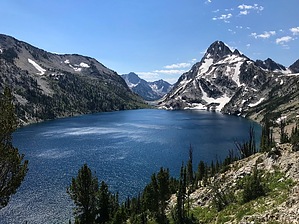
The Namesake Lake of the Wilderness
by FOTG

  Likely In-Season!
Overview
Sawtooth Lake is perhaps one of the best of the many scenic and spectacular lakes that comprise the Sawtooth Wilderness. In fact, if one was passing through and could only do one day hike in the wilderness, it would be hard not to consider this hike as an option.


Hike
From the trailhead parking lot continue to the informational kiosk and trail register. All trail users must fill out a permit onsite and attach it to their pack before entering the wilderness. This includes day hikers and backpackers. There is no fee for the permit.
remove free decal offer
After filling out your permit, continue to the trail, immediately passing the wilderness sign. The sounds of a rushing creek will accompany you on the first portion of your hike, take a right at the first signed junction and continue as the trail slowly begins to climb at a very manageable grade. Continue to Sawtooth Lake at the second signed junction, which somewhat coincides with the beginning of the slightly steeper grade that takes you to Alpine Lake. A flatter section and creek crossing in a meadow-like area will give you a slight reprieve from the elevation gain. A short spur trail to the left will take you down to Alpine Lake, otherwise continue.

The trail steepens some more out of Alpine Lake as it makes its final climb to Sawtooth Lake. However, the grade still remains moderate throughout this portion and the hiking is rather easy on the usually immaculate trail. After some prominent switchbacks above Alpine Lake, you reach the final stretch to the lake, as the trail loses its steepness. Upon reaching the lake you may take in the views or take the trail right around the lake for some better views of the stunning lake. A trail also intersects from the left as well for further exploring and connecting options. When finished, return the way you hiked in.

2023-07-12 FOTG


    Check out the Official Route and Triplogs.
    Leave No Trace and +Add a Triplog after your hike to support this local community.
    WARNING! Hiking and outdoor related sports can be dangerous. Be responsible and prepare for the trip. Study the area you are entering and plan accordingly. Dress for the current and unexpected weather changes. Take plenty of water. Never go alone. Make an itinerary with your plan(s), route(s), destination(s) and expected return time. Give your itinerary to trusted family and/or friends.

     Permit $$
    None


     Directions
    or
     Road
    FR / Dirt Road / Gravel - Car Okay

    To hike
    From Stanley travel approximately 2.5 miles west on ID-21. Turn left onto the signed FR 619 and continue another 2.7 miles to the well-signed trailhead for Iron Creek, which is adjacent to the Iron Creek Campground.
    page created by HAZ_Hikebot on Jul 12 2023 7:52 pm
     90+° 8am - 6pm kills
    helpcorrectionissue

    end of page marker