Route Editor

| Guide | ♦ | 31 Triplogs | 2 Topics |
details | drive | no permit | forecast | map |
stats |
photos | triplogs | topics | location |
| 388 | 31 | 2 |
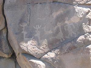
moderate by Randal_Schulhauser   From the windmill trailhead on FR481, head due west about half a mile until you reach the hilltop. The trail will only appear as a faint cow path. Elevation gain is only about 250 feet. From the hilltop are views of Perry Mesa and the grassy plains. The Bradshaw Mountains dominate the view to the west. We were fortunate to observe a herd of antelope just to the north from our vantage point. On a heading of 241 degrees (or West-SouthWest heading) from the hilltop, hike about 2 miles until you reach the rim of Perry Tank Canyon. Again, the trail will only appear as a faint cow path. You will pass under some high voltage transmission lines about 1/4 mile before reaching the rim. The ruins will become obvious near the rim, appearing only as stone rubble walls. They are extremely weathered and in relatively poor shape. The compound has multiple pueblos, the largest consisting of 50 plus rooms. The Perry Mesa settlements were occupied primarily during the fourteenth century. This places the age of the ruins comparable to those found in the Cherry Creek region. The contrast between the state of the ruins is startling! From the windmill trailhead on FR481, head due west about half a mile until you reach the hilltop. The trail will only appear as a faint cow path. Elevation gain is only about 250 feet. From the hilltop are views of Perry Mesa and the grassy plains. The Bradshaw Mountains dominate the view to the west. We were fortunate to observe a herd of antelope just to the north from our vantage point. On a heading of 241 degrees (or West-SouthWest heading) from the hilltop, hike about 2 miles until you reach the rim of Perry Tank Canyon. Again, the trail will only appear as a faint cow path. You will pass under some high voltage transmission lines about 1/4 mile before reaching the rim. The ruins will become obvious near the rim, appearing only as stone rubble walls. They are extremely weathered and in relatively poor shape. The compound has multiple pueblos, the largest consisting of 50 plus rooms. The Perry Mesa settlements were occupied primarily during the fourteenth century. This places the age of the ruins comparable to those found in the Cherry Creek region. The contrast between the state of the ruins is startling!For me, the main attraction of the site is the plethora of petroglyphs. Clusters of petroglyphs are located about 50 feet down from the rim on the west side and east side of the main ruins. The approach from the east side makes for easier access. One of the more noteworthy rock art symbols is that of a duck. The duck appears along with two deer and a human form on a rock face just below the east approach. Check out the Triplogs. Leave No Trace and +Add a Triplog after your hike to support this local community. | |||||||||||||||||||||||||||||||||||||||||||||||||||||||||||||||||||||||||||||||||||||||||||||||||||||||||||||||||||||||||||||||||||||||||||||||||||||||||||||||||||||||||||||||||||