 Route Editor

| Guide | ♦ | 6 Triplogs | 0 Topics |
details | drive | permit | forecast | route |
stats |
photos | triplogs | topics | location |
| 105 | 6 | 0 |
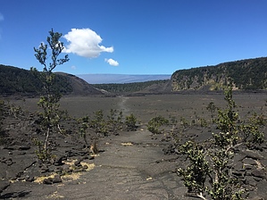
Best of the Best! by imike Back in 1959, Kilauea Volcano erupted through a vent some 400' above the bottom of an isolated basin, ...at the time close to 900' deep. After spewing out a 1900' tall spout of molten lava, and filling the basin over 400' deep in lava, eventually the boiling lake hardened into the interestingly crusted and faulted surface that still spews steam out of various cracks along the bottom section of this loop trail. Now, only 500' deep, the valley is an impressive and accessible example of the forces at play within the park.
There are also some connecting trails leading off and away towards the main Kilauea crater... but most of the trails in that section remain closed and off limits; toxic off gassing has closed down the driving and hiking access to that main event. Fortunately, there are nice overlooking hikes that skirt the area... and if you have the time, plan on doing those various connecting routes. This is a National Park... complete with entry fee. Check in at the Visitor Center for hike details and current hazards and closures. Being the most accessible of all the trails, and the one most popular... consider getting up early to beat the crowds. Check out the Official Route and Triplogs. Leave No Trace and +Add a Triplog after your hike to support this local community. One-Way Notice This hike is listed as One-Way. When hiking several trails on a single "hike", log it with a generic name that describes the hike. Then link the trails traveled, check out the example. | |||||||||||||||||||||||||||||||||||||||||||||||||||||||||||||||||||||||||||||||||||||


