Route Editor

| Guide | ♦ | 58 Triplogs | 2 Topics |
details | drive | permit | forecast | route |
stats |
photos | triplogs | topics | location |
| 341 | 58 | 2 |
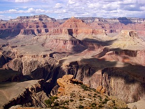
Bushwhacking - THE BOMB! by BACKROADER   Millions of people from all over the world flock to the Grand Canyon every year to see its majesty and awe-inspiring beauty. While this is great for our Arizona economy, it has proven to be a literal "zoo" (especially during peak summer vacation season). This scramble is dedicated to many an adventuresome hiker who enjoys solitude and who is determined at all costs to get away from the camera clicking multitudes! Millions of people from all over the world flock to the Grand Canyon every year to see its majesty and awe-inspiring beauty. While this is great for our Arizona economy, it has proven to be a literal "zoo" (especially during peak summer vacation season). This scramble is dedicated to many an adventuresome hiker who enjoys solitude and who is determined at all costs to get away from the camera clicking multitudes!Fear not my friends! If you long remote solitude in your visits to the Grand Canyon then this route is for you. If you don't mind bushwhacking, are not afraid of heights, have minimal rock climbing expertise, and have hawk-like, cairn spotting eyes, then it's time to set sail for The Battleship.
This scramble might seem like a walk in the park for those of you that have logged at least 200 previous canyoneering miles to more remote places with names like Sockdologer Rapids, Cheyava Falls, Boucher, Comanche Point, Thunder River, or anyone who has braved the Esplanade west of Mount Huethawali to Royal Arch Creek, or even jogged down to Plateau Point for a nice sunset then back up to the rim by moonlight! Yes, to all of you "Canyon Junkies" that have J.W. Powell, Harvey Butchart, George Steck, Stewart Aitchison, Colin Fletcher, or John Annerino on your bookshelves, this will turn out to be a long day hike. For those who are just starting to venture off the beaten path, this is a rather strenuous, ten hours (minimum), round trip of boulder hopping, bushwhacking, and route finding over trails more common to Mule Deer and Pink Canyon Rattlers than to weekend warriors. In either case, just do it! But, be prepared to feel this hike days after it is over. As a former bellman for Fred Harvey on the rim, I can confidently say that the workers know most all the animal paths inside the inner gorge, and a good friend of mine; Ken Hunter told me this is definitely one of them! To start with, before embarking on your journey, get the latest information from the Backcountry office ranger staff (perhaps they will even let you camp overnight with a permit "AT LARGE"). Make sure to leave a detailed time schedule and check back either in person or with a phone call after your hiking party is out of the canyon. Then take the East Rim Shuttle out to Powell Memorial overlook and gaze down upon your destination, the unmistakable and foreboding Battleship! You will see it guarding the inner gorge with its full armor and double smokestacks. Perhaps you may even spot with a powerful set of binoculars the ever-faithful Red, White, and Blue banner of freedom waving at the fifty-yard line of its football field-sized summit. Starting at an elevation of 6800 feet, this hike actually follows the first two miles of the crowded Bright Angel Trail down past the 1.5-mile watering hole and rest stop, up to the aptly named "Two Mile Switchback" (Elevation 5490 ft.) where a sign posted marks the location and a huge switchback heads sharply right. This is where you want to turn left and bushwhack your way in a somewhat northerly direction across the red Hermit Shale/Supi sandstone away from the switchback. The part directly after the two-mile sign is the most difficult to navigate because of a drainage and numerous bushes but, as you leave the loud crowds behind you the going will eventually be faster. Soon you will spot small guiding cairns and remember this is mostly a horizontal scramble at no time leaving the Hermit formation in and out of large drainage's. Just know that at times the cairns are washed away from storm damage while at other times the route may even resemble a fairly level trail as it gets closer to the flat saddle nearly a mile due north of the 2 mile jump off. This flat saddle has fantastic views both east and for the first time west looking into the inner gorge. There is no source of water anywhere along the route after leaving the Bright Angel trail, but sometimes water stagnates into small pools called tienas only shortly after heavy rainstorms. There are many Pinion Juniper Pine trees for shade at the saddle with numerous huge boulders and flat spots to pitch a tent. In fact, this is the only area that is suitable for a potential at-large campsite. Directly north of the saddle starts your approximately one mile/roughly 1000 foot ascent of The Battleship. Heading around the Southeast slope a faint route marked with cairns will start to climb sharply up passing many large boulders. The ascent of the East slope follows this faint scramble up to a large crack in the red sandstone. There are many cairns to guide but note that it is through this crack that requires a small bit of climbing that you must pass. Temperatures in the summertime can be dangerously extreme, even deathly along this stretch of the route as it is fully exposed to the midday peak of sunshine and no shade is to be found but inside the crack. At one point there is a scary, somewhat exposed section that needs to be negotiated by bracing your back up against one side of the crack and wedging yourself inch by inch higher. This is roughly an eight-foot section that a friend and I had to help pull our wives up through. Anyone afraid of heights may have trouble here as there is a very scenic yet void drop below this wedged in boulder. Notwithstanding, there were no ropes just a determined mindset required. Just after each step up through the two cracks, you climb to another level and eventually up to the flat summit experiencing a 360-degree view of the canyon as if you were on your own private island. On each hiking occasion spanning a ten-year timeframe, there was a United States flag pitched atop a monster battleship replica cairn that will put goosebumps on you the first as well as many future times thereafter you bring friends back to see it. Check out the Official Route and Triplogs. Note This is a moderately difficult hike. Leave No Trace and +Add a Triplog after your hike to support this local community. | ||||||||||||||||||||||||||||||||||||||||||||||||||||||||||||||||||||||||||||||||||||||||||||||||||||||||||||||||||||||||||||||||||||||||||||||||||||||||||||||||||||||||||||||||||||||||||||||||||