Route Editor

| Guide | ♦ | 1 Triplog | 0 Topics |
details | drive | permit | forecast | map |
stats |
photos | triplog | topics | location |
| 22 | 1 | 0 |
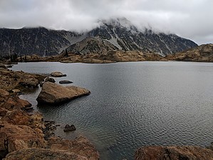
From its junction with trail 1394, this trail heads uphill through forest for about 1 mile until it switchbacks up through open meadow and scattered trees to a junction with Longs Pass Trail 1229. Past this junction, the trail crosses a small basin and begins climbing steeply towards the ridgetop through an area of rock, scattered small trees, and patchy meadows. Views of the surrounding country get better as the trail heads up. From the ridgetop there are excellent views of surrounding peaks, including Mount Stuart. The trail then crosses the ridge at the wilderness boundary and enters the Wenatchee River Ranger District. At this point an upper trail traverses Headlight Basin as the most direct route towards Ingalls Lake, whereas the lower trail, which has more campsites, is less direct but rejoins the upper trail before the lake. Near the lake, the trail heads steeply uphill through rocks, over a rocky ridge and ends at the lake. A scramble around the west side of the lake will rejoin a trail that traverses to Stuart Pass which is the termini of the Ingalls Creek and Jack Creek trails.
Check out the Triplog. Leave No Trace and +Add a Triplog after your hike to support this local community. | ||||||||||||||||||||||||||||||||||||||||||||||||||||||||||||||||||||