Route Editor

| Guide | ♦ | 170 Triplogs | 10 Topics |
details | drive | no permit | forecast | 🔥 route |
stats |
photos | triplogs | topics | location |
| 1.7k | 170 | 10 |
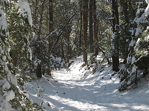
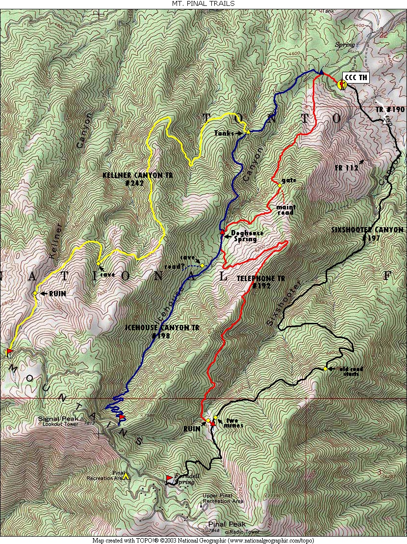
a very continuous climb by Fritzski  History HistoryAugust Pieper arrived in Globe in 1883 from Silver City, NM. He dug tanks in what came to be known as Icehouse Canyon. When these were filled with water and froze, Pieper cut and stored the ice. He hauled it into Globe by ox team and sold it for twenty-five cents a pound, mainly to saloons. Prologue The Icehouse Canyon Trail is one of a group of four main trails climbing the north slope of Mt. Pinal. The elevation and north-facing slopes combine to create a surprisingly lush alpine microenvironment and some very enjoyable hikes. I believe the stands of Aspen near the top may be the closest to the Phoenix area to be found. If you can catch this area when the leaves are turning, it just doesn't get much better.
The Icehouse trail, even more than the others, disguises a real workout with relaxing beauty. All of the trails generally start at the same 4500' elevation trailhead and finish near the top of the mountain at over 7500'. On the Icehouse, the climb is particularly unrelenting, accomplishing the gain in just 5 miles as opposed to its 6-mile sister trail, the Sixshooter/197. These trails are also popular with mountain bikers and from what I understand, best enjoyed as a one-way downhill via car shuttle. One reason this area doesn't see more use is the lack of available resources describing the confusing network of roads and trails. I'm not sure why these trails are not shown on the USGS topos, but I have included GPS trail depictions and a road map that I hope will help the cause. Hike The Icehouse Canyon Trail #198 actually begins as the Telephone Trail #192 leaving the west side of the large Icehouse CCC Recreation Site/Trailhead. From the sign, proceed through some manzanita scrub for about .2mi to the signed Icehouse Tr/198 intersection and go right. Head down across Icehouse Creek and up the other side and onto an old closed road. Follow the road for a short distance and watch for the trail to begin again on the left. You are now on the dry west slope of the canyon where the trail quickly deposits you back out onto the road. This rather steeply climbing road continues to the 1.3mi point where you come across a grouping of old water tanks and the signed Kellner Canyon Tr/ #242 intersection. Remain straight uphill on the old road as it cuts above a steep rocky canyon and finally reaches the first stands of pine trees. From here the trail changes character as it gradually enters the shadiness of a thick forest. At about the 2.3mi point the trail crosses Icehouse Creek where it once again rejoins the Telephone Trail #192 coming in from the left at Doghouse Spring. From what I could tell this "spring" is the small hole in the middle of the trail that is full of water and the "ruins" of an old cabin are a pile of boards. Nonetheless, a very pretty little spot. The Icehouse and Telephone trails run together here for only about 200' where the Telephone quickly departs again up the east slope to connect over to the Sixshooter Trail. From here continue upstream crossing the creek several times. Soon you will come to a fork of sorts. The trail up to this point seems to be the remnants of an old logging road and at the fork, it begins to head up to the right out of the creek bed. We followed it a short distance to the remains of an old mine shaft. Apparently, it goes up to a spring at some point. Stay in the creek bed and carefully follow the beaten path through many fallen small timbers. As you proceed further, the trail becomes more easily discernable. Continue up until nearing the head of the canyon. At about 4mi you will see a rock cairn marking the point where the trail cuts back to the left and departs the creek bed up the slope. Follow some steep switchbacks till you finally top out on a small pullout road just off the main FR651. There are some nice spots to get a breather and a snack here before heading back down the same way. We opted to join the lower half of the Telephone Trail on our return to the trailhead and found it to be much nicer than the lower half of Icehouse and would recommend it as the preferred route between the two. Looking at the trail depictions, you can see that every trail offers an opportunity for several "loop" routes. Just use your imagination and enjoy!
Check out the Official Route and Triplogs. Leave No Trace and +Add a Triplog after your hike to support this local community. | |||||||||||||||||||||||||||||||||||||||||||||||||||||||||||||||||||||||||||||||||||||||||||||||||||||||||||||||||||||||||||||||||||||||||||||||||||||||||||||||||||||||||||||||||||||||||||||||||||||||||||