Route Editor

| Guide | ♦ | 52 Triplogs | 6 Topics |
details | drive | no permit | forecast | 🔥 route |
stats |
photos | triplogs | topics | location |
| 520 | 52 | 6 |
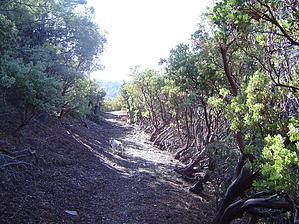
A Pleasant Cruise by Fritzski   The Kellner Canyon Trail #242 is one of a group of four main trails climbing the north slope of Mt. Pinal. The elevation and north-facing slopes combine to create a surprisingly lush alpine microenvironment and some very enjoyable hikes. I believe the stands of Aspen near the top may be the closest to the Phoenix area to be found. If you can catch this area when the leaves are turning, it just doesn't get much better. The Kellner Canyon Trail #242 is one of a group of four main trails climbing the north slope of Mt. Pinal. The elevation and north-facing slopes combine to create a surprisingly lush alpine microenvironment and some very enjoyable hikes. I believe the stands of Aspen near the top may be the closest to the Phoenix area to be found. If you can catch this area when the leaves are turning, it just doesn't get much better.Although some old mine shafts still dot the area, it is noted mainly for its logging history. Many of the trails, and this trail, in particular, are remnants of old logging roads and ruins are numerous.
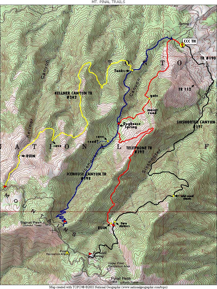
One reason this area doesn't see more use is the lack of available resources describing the confusing network of roads and trails. As old as they obviously are, I'm not sure why these trails are not shown on the USGS topos, but I have included GPS trail depictions and a road map that I hope will help the cause. The Kellner Canyon Trail #242 actually begins as the Telephone Trail #192 leaving the west side of the large Icehouse CCC Recreation Site / trailhead. From the sign, proceed through some manzanita scrub for about .2mi to the signed Icehouse Tr #198 intersection and go right. Head down across Icehouse Creek and up the other side and onto an old closed road. Follow the road for a short distance and watch for the trail to begin again on the left. You are now on the dry west slope of the canyon where the trail quickly deposits you back out onto the road. This rather steeply climbing road continues to the 1.3mi point where you come across a grouping of old water tanks and the signed Kellner Canyon Tr #242 intersection. The Kellner Canyon Trail officially begins here, and despite its name, only the very last section of the trail is actually in Kellner Canyon. Most of the trail is a matter of ridge hopping to the west to finally access the canyon near the top. From the intersection head west through scrub and manzanita that gradually transition to pine forest as you climb each successive ridge. At about the 3.5-mile point in the last thickly forested drainage prior to Kellner, you'll come across an old cave/mine shaft filled with water. From here the climb eases up and you finally round the last ridge and head up the east slope of Kellner Canyon. Soon you will come to the open area of Kellner Canyon Spring. There are many old logging artifacts such as large boilers and mechanical parts from an old steam engine lying around. Curiously, there was nothing that resembled the remnant of a spring. Supposedly there were also several cabins here many years ago. From here continue up into the creek bed and follow the cairns as the trail wanders back and forth until finally departing sharply up to the right. The climb here is steep, but short to the top at FR651. Here you'll find a pleasant open parking area for the signed upper trailhead. This trail is a wide-open cruiser, and you can plan on making really good time. Looking at the trail depictions, you can see that every trail in the area offers an opportunity for several "loop" routes. Just use your imagination and enjoy!
Check out the Official Route and Triplogs. Leave No Trace and +Add a Triplog after your hike to support this local community. | |||||||||||||||||||||||||||||||||||||||||||||||||||||||||||||||||||||||||||||||||||||||||||||||||||||||||||||||||||||||||||||||||||||||||||||||||||||||||||||||||||||||||||||||||||||||||||||||||||||||||||||||||||||