Route Editor

| Guide | ♦ | 18 Triplogs | 1 Topic |
details | drive | no permit | forecast | 🔥 route |
stats |
photos | triplogs | topic | location |
| 207 | 18 | 1 |
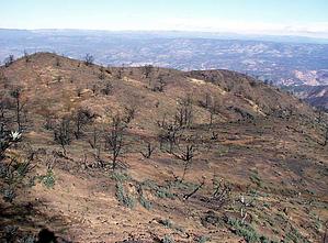
In the Shadow of North Peak by conform6073   Knob Mountain is visible from the trailhead and a few other locations along the way, but it's really not very impressive and it's pretty far away, so one assumes that nearer and bolder-looking features are the destination. Only when you are almost there do you realize you've been looking toward the wrong peaks the whole way. Knob Mountain is visible from the trailhead and a few other locations along the way, but it's really not very impressive and it's pretty far away, so one assumes that nearer and bolder-looking features are the destination. Only when you are almost there do you realize you've been looking toward the wrong peaks the whole way.From the parking area, the trail leads south across FR 406 and City Creek and then heads upstream, parallelling the creek but moving gradually away from it to the west and above it. Within the first quarter mile, one encounters evidence of the fire of summer, 2004, mainly charred shrubs and small trees. About a mile along, the path veers sharply west, climbing a low ridge and leaving the fire damage, temporarily, behind. For another mile or so the way continues through unburned mainly pinion and juniper woods at a gentle grade; and as the closeness of the live trees prevents any long views forward, side or back, the gaze is drawn upward to the hulk of North Peak straight ahead. North Peak will dominate the field of vision to Knob Mountain.
Because no trees remain in the way, good views to the north and east accompany the hiker until the trail levels off above 6,000 feet about a half mile short of the summit. Here sizable areas of vegetation are unburned, a refreshing sight after several miles of traversing near-moonscape terrain. The top of Knob Mountain did burn, but other than North Peak, now very close at hand, views from there are not impressive. Check out the Official Route and Triplogs. Leave No Trace and +Add a Triplog after your hike to support this local community. | ||||||||||||||||||||||||||||||||||||||||||||||||||||||||||||||||||||||||||||||||||||||||||||||||||||||||||||||||||||||||||||||||||||||||||||||||||||||||||||||||||||||||||||||||||||||||||||||||||||||||