Route Editor

| Guide | ♦ | 4 Triplogs | 0 Topics |
details | drive | permit | forecast | route |
stats |
photos | triplogs | topics | location |
| 71 | 4 | 0 |
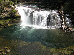
Great rewards by sagamihara_hiker From the Lower Lewis River Falls Trailhead make your way down any of the use paths to views of Lower Falls. The trail on the edge of the bluff is the Lewis River Trail (#31). Walk to the right as far as you like for different views of the waterfall. Continue past the trailhead and the restrooms. This first part of the trail travels through the large campground. There are lots of use paths, but if you stay right, you can't go wrong. Soon you'll climb a small hill to the edge of the campground. There's a sign here marking the Lewis River Trail. Continue east up the hill and head upriver. The trail soon passes quite near FR 90 and you may hear and see cars. After a bit though the trail drops away from the road. There's a small footbridge above a seasonal waterfall. This bridge is currently unsafe (July 2010) and closed but you can cross the small creek just upstream of the bridge.
Back on the main trail you'll walk about a mile to the base of Upper Falls. The next part of the trail is a steep climb, but the climb is short and the rewards are great. The trail works up the side of the Alec Creek Canyon gaining about 150 feet in a quarter mile. Then the trail heads back along the top of the bluff to the top of Upper Falls. There's a short side trail that leads down to a couple of great views. The last waterfall is the smallest of the bunch, but it's only a 1/4 mile, so it's worth the trip. This is Taitnapum Falls. Return the way you came. Check out the Official Route and Triplogs. Leave No Trace and +Add a Triplog after your hike to support this local community. | ||||||||||||||||||||||||||||||||||||||||||||||||||||||||||||||||||||||||||||||||||||||