Route Editor

| Guide | ♦ | 63 Triplogs | 4 Topics |
details | drive | no permit | forecast | 🔥 route |
stats |
photos | triplogs | topics | location |
| 693 | 63 | 4 |
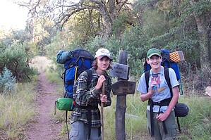
Great beginning, briars galore! by jbhunsaker  This hike begins at the Campaign Trailhead at the southern tip of Forest Road 449A. 449A is a 4X4 road that winds through sandy washes, wet ravines, and a couple of steep hills. You can make it through during dry seasons in a high clearance 2-wheel drive, but this means you will be packing extra water for the trip since water is scarce. This hike begins at the Campaign Trailhead at the southern tip of Forest Road 449A. 449A is a 4X4 road that winds through sandy washes, wet ravines, and a couple of steep hills. You can make it through during dry seasons in a high clearance 2-wheel drive, but this means you will be packing extra water for the trip since water is scarce.Park at the trailhead and start down the road toward Reavis Mountain School Sanctuary. Turn right onto the trail at the hiking sign after about 0.2 mi. and the Campaign Trail sign is within sight. Follow the trail through the creek bottom, crossing the creek several times. The trail then climbs up along a ridge where you will have a beautiful view of the School/Sanctuary to your left. At 1.2 mi., you will come to the Reavis Gap/Campaign Trail intersection. The Reavis Gap trail goes to the right and is a beautiful hike... sometimes brutal but certainly beautiful once you climb out of the creek bottom. During dry seasons, this will be the last water you see until arriving at Reavis Creek. The Reavis Gap trail follows to the right Reavis Gap Canyon marked by several sheer drop-offs. There are 3 fairly steep climbs up to the top of Two Bar Ridge at 2.8 mi. The footing can be slippery with loose pebbles and rocks. There are several nice places to rest in meadows of knee-high foliage under mesquite trees. The Two Bar Ridge/Reavis Gap trail sign (3.2 mi) is a welcome sight as you drop down off the ridge to about 4800 feet.
Continue your hike by heading south on the Reavis Ranch trail to the Fire Line trail intersection (N33 29.225 W111 09.266) where the trail crosses Reavis Ranch Creek. This was a bit difficult for us to find with many different trails leading through the tall grass to various campsites. The Fire Line Trail is an old bulldozer trail heading east. This trail gradually gains altitude from 4900 at the creek to 5500 through mostly chaparral brush and pinon-juniper before starting its descent. There is a nice side trip you can take up to Circlestone at the 8.6-mi point. This trail is marked by cairns and heads south up the hill. This trail is steep at first, then changes to an easy, steady climb up to circle rock. For more information about Circlestone, reference it on the HAZ TrailDex. From this point, the trail heads down steeply. The footing can be tricky in spots with the trail mostly being gravel and lose rock. We were thankful we did not come up this way. Fireline intersects the Campaign Trail after crossing the Campaign creek (N33 28.566 W111 06.841) at 10.2 mi. From here head north on the Campaign trail. It mostly follows the creek that has seasonal water. It is a difficult trail to follow because it is not well maintained. There are many cairns to help you, and the trail is mostly on the west side of the creek. However, it crosses the creek frequently and there is a lot of brush and briars. Again, long pants and long sleeves are a good idea. This loop will bring you back to the Campaign/Reavis Gap intersection at 14.2 mi. Follow the trail back to the trailhead for a total of 15.3 mi. Reavis Ranch and Circlestone were the highlights of this trip. The scenery and views were breathtaking. We were not impressed with the Campaign Trail. While mostly flat, it left much to be desired because it was hard to follow in many spots, its poor maintenance, and did I mention the briars? Check out the Official Route and Triplogs. Leave No Trace and +Add a Triplog after your hike to support this local community. | |||||||||||||||||||||||||||||||||||||||||||||||||||||||||||||||||||||||||||||||||||||||||||||||||||||||||