Route Editor

| Guide | ♦ | 1 Triplog | 0 Topics |
details | drive | no permit | forecast | map |
stats |
photos | triplog | topics | location |
| 13 | 1 | 0 |
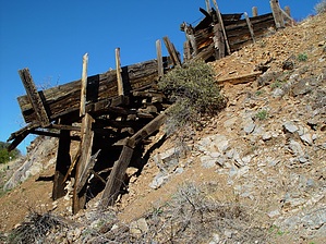
Mines by HAZ_Hikebot   Overview OverviewHike 1.75 miles up FS 192B to the wilderness boundary. You can drive up and shave 3.5 miles off this hike. Off trail hike the rim southwest about 1 mile to Musk Hog Canyon. Drop down into Musk Hog and follow to Fraser Canyon. Cut over the low peninsula to Fraser Canyon and head up to Whetrock Canyon. Bring it home following Whetrock Canyon back up to the ridge. Check out the Triplog. Note This is a moderately difficult hike. Leave No Trace and +Add a Triplog after your hike to support this local community. | |||||||||||||||||||||||||||||||||||||||||||||||||||||||||||||||||||||||||||||||||||||||||||