Route Editor

| Guide | ♦ | 22 Triplogs | 0 Topics |
details | drive | permit | forecast | route |
stats |
photos | triplogs | topics | location |
| 100 | 22 | 0 |
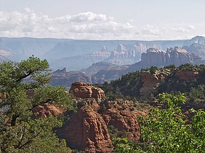
3 small valleys & a volcano by montezumawell  The Turkey Creek Trail #92 doesn't follow a creek, and there's no flowing water to be seen. However, it is a pleasant stroll through Red Rock Country's fringe to the flanks of a shield volcano where a fine panorama and intriguing geology await. The Turkey Creek Trail #92 doesn't follow a creek, and there's no flowing water to be seen. However, it is a pleasant stroll through Red Rock Country's fringe to the flanks of a shield volcano where a fine panorama and intriguing geology await.The actual Turkey Creek Trailhead lies a half-mile off Verde Valley School Road. But a rough half mile it is. Low slung rental cars are often seen at the TH. However, we think you'd prefer to traverse this bedrock-studded road with a higher clearance vehicle.
The Turkey Creek Trail ambulates through three small valleys, each smaller than the preceding one. The pinon-juniper forest here shows remarkably little mortality from the recent beetle infestation. For the first 1.5 miles, you will be hiking on an old road. The route was bulldozed out decades ago to help create Turkey Creek Tank. One guidebook states that the Turkey Creek TH is located on the NW side of this stock water impoundment. There is a stout metal trail sign there. However, in recent years, the actual TH has migrated 1.5 miles back to the parking area. The stroll between the parking area and Turkey Creek Tank is quite lovely. Occasional open areas provide excellent localized views. After passing the stock tank, the trail passes through a somewhat more heavily vegetated vicinity. You gradually gain elevation as you approach a short, steep final climb onto the lip of the House Mountain caldera. There are fine views of a red rock panorama stretching between Bear and Munds Mountains at the top. You can also see the volcanic caldera and the west vent from which the mountain derived its place name. Motorized vehicles can reach this point from a very rough road coming in from the south. We've never encountered a vehicle here, but we've seen fresh tire tracks. If you wish to continue up to the eastern volcanic vent, and even more sweeping panorama awaits. However, this is a rough, challenging SOB route. (SOB: "Sea of Basalt.") House Mountain is a 13-15 million-year-old shield volcano. The mountain's geologic secrets were only recently deciphered in the late 1980s. Geologist Wayne Ranney used a small outcrop near the Turkey Creek Trail's upper terminus to prove that House Mountain erupted at the base of the "ancestral" Mogollon Rim. The mountain's presence can therefore be used to show that the Rim has been eroding to the northeast at the rate of one foot every 625 years. That's quite fast in geologic time. The telltale outcrop is located perhaps a quarter-mile easterly from where the Turkey Creek Trail tops out. It's easier to see while hiking up the side of the caldera. Author Ranney has assured us that it's a "doable" hike. But it looks like a very sketchy bushwhack to us. Look for a small volcanic cinders area sitting in contact with the much older sedimentary rocks for which Sedona is famous. You can read more about House Mountain and the Sedona/Verde Valley vicinity in Ranney's book, "Sedona Through Time." The 7 miles round trip on the Turkey Creek Trail usually takes about 3-3.5 hours. Allow an extra hour or two if you plan to explore other portions of House Mountain. Recently, we've hiked this trail three times in late 2004 and early 2005. The tread is in great shape. If you wanted to make this trail part of an all-day Sedona adventure, you could easily combine the Turkey Creek Trail with a hike on portions of the Baldwin, Templeton, and Cathedral Rock Trails. Figure about 3-3.5 hours for a leisurely hike to the Cathedral Rock saddle from another trailhead at the northern end of Verde Valley School Road. It's not far from the Turkey Creek TH. Taken together, these two hikes would make a nicely matched morning-afternoon pair. On another note, the East Entrance to Red Rock State Park is located about a quarter-mile from the Turkey Creek TH. It is a pedestrian-only entrance. Hikers must pay $2 ( 2005 ) at the fee/info kiosk inside the Park. There are perhaps 5-6 miles of well-maintained, interesting trails inside the park, as well as toilets, water, and a visitor center. To find the Park entrance walk a few minutes west on 9892 until you see the sign.
Check out the Official Route and Triplogs. Leave No Trace and +Add a Triplog after your hike to support this local community. | |||||||||||||||||||||||||||||||||||||||||||||||||||||||||||||||||||||||||||||||||||||||||