Route Editor

| Guide | ♦ | 12 Triplogs | 0 Topics |
details | drive | no permit | forecast | 🔥 route |
stats |
photos | triplogs | topics | location |
| 164 | 12 | 0 |
Mining Bushwhack by Tim   This 6.5-mile loop hike starts from the Woodbury Trailhead and heads out the Coffee Flat Trail to Fraser and Whetrock canyons' junction. The return trip up Whetrock Canyon is an off-trail adventure leading to a couple of mines before exiting onto an old Forest Service Road to return to the trailhead. The hike is best described in Carlson's "Hiker's Guide to the Superstition Wilderness" under trip #51. This 6.5-mile loop hike starts from the Woodbury Trailhead and heads out the Coffee Flat Trail to Fraser and Whetrock canyons' junction. The return trip up Whetrock Canyon is an off-trail adventure leading to a couple of mines before exiting onto an old Forest Service Road to return to the trailhead. The hike is best described in Carlson's "Hiker's Guide to the Superstition Wilderness" under trip #51.Carolyn and I set out on a beautiful Saturday morning on January 29th at 10:00 with temperatures in the mid-'60s. Rather than park at the Woodbury Trailhead itself, we parked a little way up the road from the Woodbury turnoff right next to the gate blocking the road to the JF Ranch. This parking selection probably shaved off 1/2 mile of road hiking from the loop. We were expecting this 6.5-mile hike (now closer to 6 miles) to be a 3+ hour "cupcake", with the most significant challenge being some potential creek bed "boulder hopping" in Whetrock Canyon. Once again, I underestimated the Superstitions. (smile)
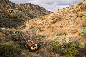
After about a 1/2 to 3/4 mile trek, one can see the upper mine's tailings way at the canyon's end. It turns out that this is the hike's exit out of Whetrock Canyon. Further up the canyon, the creek bed becomes more of a steep ravine. (On the topo map, this occurs shortly after the "n" in canyon.) Once we got down in the bottom of this ravine, we lost sight of the upper mine tailings, representing our bearing line. We knew we were on track when we came across the remains of the old dairy truck. This is where we made our first mistake. We continued up the relatively clear drainage containing the dairy truck, thinking that it would eventually lead to the old "road" servicing the mines. How else would the dairy truck get to where it was? However, this drainage wound around and was taking us too far north from our bearing line. After a short while, this drainage became impassable due to the undergrowth. At this point, Carolyn suggested backtracking to the dairy truck and looking for another way, which she did. I scrambled up the drainage (i.e., hikers right) and stumbled upon the tailings of the first (i.e., the lower), mine. I yelled down to Carolyn, and she ended up backtracking about 30 yards past the dairy truck and came around and up the other drainage to the right. From there, it was a much easier scramble up to where I was at the lower mine. (Carlson's book suggests scrambling directly up the slope above the dairy truck, which would work too, but Carolyn's way was easier, I think.) There's an old refrigerator and cement trough just to the right of these tailings. The mine entrance itself has been closed off with a dirt cave in. This is where we made our second mistake. From this lower mine, we could make out the remains of a faint road heading down and across the drainage to the south (hiker's right) and heading up a ridge. We went this way as we thought, incorrectly, that this was the former mine road providing our exit. Once we climbed up the ridge on the other side, we saw the error of our ways. From this higher vantage point, we could make out the tailings of the upper mine and, more importantly, what appeared to be a "road" winding up the slope between the upper and lower mine. Once again, at Carolyn's urging, we headed back to the lower mine and found this "road" climbing out in a northerly direction. While we were resting at the lower mine, we heard ATVs' rumble above us and could make a few riders above the upper tailings. (Apparently, they disregarded the "No Motor Vehicles" sign at the Wilderness Boundary, which is around the corner from the upper mine.) At its beginning at the lower mine, the "road" is nothing more than a path clear of trees & scrub brush and covered in rocks and grass, which even ATVs would have difficulty negotiating. It is this grass that outlined the path and made it visible from across the canyon. The path then cut back across the slope's face before switching back in front of the upper mine. The further up we climbed, the more distinct this path became. When we got to the upper mine entrance, the path resembled a narrow road covered in ATV tracks. From here, we hiked around the hill to the intersection with the former Forest Service Road #192B. We followed this road for about a mile until we branched out on the shortcut to Woodbury Trailhead. The shortcut is a former FS Road and shown on Carlson's map. It is marked with a post and sign declaring "No Motor Vehicle Access". From this point, we could make out the Woodbury Trailhead and our Jeep in the distance. All in all, the hike measured 6.5 miles and took us 4 1/4 hours. We probably could have done it in 3 1/2 hours without as much water and our misdirection around the lower mine. Gate Policy: If a gate is closed upon arrival, leave it closed after you go through. If it is open, leave it open. Leaving a closed gate open may put cattle in danger. Closing an open gate may cut them off from water. Please be respectful, leave gates as found. The exception is signage on the gate directing you otherwise. Check out the Official Route and Triplogs. Leave No Trace and +Add a Triplog after your hike to support this local community. | ||||||||||||||||||||||||||||||||||||||||||||||||||||||||||||||||||||||||||||||||||||||||||||||||||||||||||