Route Editor

| Guide | ♦ | 6 Triplogs | 0 Topics |
details | drive | no permit | forecast | map |
stats |
photos | triplogs | topics | location |
| 4 | 6 | 0 |
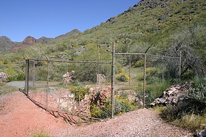
Easy trail to see mine shafts by davidmurphy  An MSC Steward writes: This site is not located on the approved trail system within the McDowell Sonoran Preserve. It was comprised of two shafts and one adit. The workings were a fraud to sell stock in the era surrounding WWI. Two of the three diggings have been sealed or filled against public access. The remaining one, while fenced, is dangerous at over 100 feet deep. There is not much to be seen here, anyway. Be safe. Stay on mapped trails. An MSC Steward writes: This site is not located on the approved trail system within the McDowell Sonoran Preserve. It was comprised of two shafts and one adit. The workings were a fraud to sell stock in the era surrounding WWI. Two of the three diggings have been sealed or filled against public access. The remaining one, while fenced, is dangerous at over 100 feet deep. There is not much to be seen here, anyway. Be safe. Stay on mapped trails.This is an easy and short hike to a few pit mines near the McDowell Mountains.
After another half-mile (total of one mile), there is a fork in the trail where there remains the dismantled rock foundation of what appears to have been a building at one time. I took the fork that headed east and began riding toward Thompson Peak. The trail started to gain some elevation here, so I chained my bike to a post and started hiking. The wildflowers were abundant on this April afternoon and, with only about two or three other hikers on this trail, the setting was peaceful and serene. At about the 1.5-mile point, other forks on this trail lead to different pit mines. I found three in all, not far from one another at about the 1.8 to 2-mile point. These old mine shafts are surrounded by barbed wire fencing, but you can get a really good look nonetheless. Near one were some remnants of old rusted pieces of iron, which have pickaxe punctures in them. Check out the Triplogs. Leave No Trace and +Add a Triplog after your hike to support this local community. | |||||||||||||||||||||||||||||||||||||||||||||||||||||||||||||||||||||||