username
X
password
register
for free!
help
 This is likely a great time to hike this trail!  Check out "Preferred" months below, keep in mind this is an estimate.
 

Marys Peak Hike, OR

Guide 5 Triplogs  0 Topics
  4 of 5  
Fav
Wish
0
details
drive
no permit
forecast
route  
stats
photos
triplogs
topics
location
67 5 0
Statistics
tap row or icons for details
Difficulty 1.5 of 5
Distance Round Trip 1.28 miles
Trailhead Elevation 3,856 feet
Elevation Gain 322 feet
Accumulated Gain 322 feet
Kokopelli Seeds 2.89
unreported if dogs are allowed
editedit > ops > dogs to adjust
feature photo
Photos Viewed All MineFollowing
Inaugural Calculation on Button Tap!
24  2022-06-01 DixieFlyer
10  2018-07-08 Oregon_Hiker
16  2013-06-28 johnlp
14  2012-08-04 johnlp
3  2009-10-31
East Ridge Trail #1324
johnlp
Author
author avatar Guides 16,843
Routes 17,472
Photos 24
Trips 1 map ( 6 miles )
Age 28 Male Gender
Location HAZ, TrailDEX
Associated Areas
list map done
North Central Region
Historical Weather
Trailhead Forecast
Radar Map
Expand Map
Preferred Jul, Aug, Sep, Jun
Sun  5:41am - 6:44pm
Official Route & 2 Rts
 
0 Alternative


remove free decal offer

 Likely In-Season!
Views by Oregon_Hiker
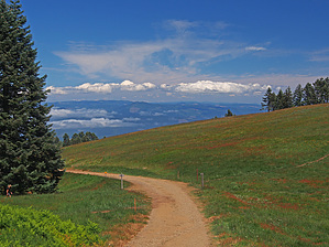
The views from the top of this highest peak in Oregon's coastal range are amazing. To the west you can see the Pacific Ocean and to the north, south and east you can see the snow capped volcanic mountains of the Cascade Range. However on this day the ocean was covered by a cloud bank below the top of Mary's Peak and the humid haze mixed with a little smoke from a fire in the Columbia River Gorge limited the views of the Cascades. So views were limited on this day but still worth the trip. Mt Rainier, Mt Hood and Mt Jefferson could be seen poking up through the haze and the cloud bank had its own beauty. I have been on this peak in the winter when an inversion layer held down the haze. The Cascade Mountains were visible all the way from Mt Baker in Washington State near the Canadian border to Mt Shasta in California.

2018-07-14 HAZ_Hikebot
  • PDF Map
    area related
    PDF Map


Check out the Official Route and Triplogs.
Leave No Trace and +Add a Triplog after your hike to support this local community.
WARNING! Hiking and outdoor related sports can be dangerous. Be responsible and prepare for the trip. Study the area you are entering and plan accordingly. Dress for the current and unexpected weather changes. Take plenty of water. Never go alone. Make an itinerary with your plan(s), route(s), destination(s) and expected return time. Give your itinerary to trusted family and/or friends.

 Permit $$
no fees or permits reported

if incorrect tell us about it


 Directions
or
 Road


To hike
page created by HAZ_Hikebot on Mar 09 2010 5:52 pm
 90+° 8am - 6pm kills
helpcorrectionissue

end of page marker