Route Editor

| Guide | ♦ | 25 Triplogs | 3 Topics |
details | drive | no permit | forecast | 🔥 route |
stats |
photos | triplogs | topics | location |
| 137 | 25 | 3 |
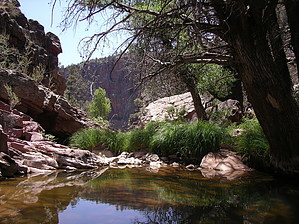
Beautiful wooded setting by te_wa   Hike HikeThis small and short hike will take you to a beautiful wooded setting at Oak Spring. It starts on the Hardscrabble Road near the town of Pine and takes you into a shaded creekside area, and continues at a mildly downhill rate for 1.75 easy miles. A large meadow neighbors the area around Oak Spring with tall grasses, the usual junipers, manzanita, and of course, oaks. The spring was flowing in May, and I imagine it would be enough to fill a bottle even in dryer months. Explore At the Oak spring area, two trails are connecting. One is the Oak Trail #16 to Pine trailhead 3.5 miles long heading due East. The other is the Walnut Trail #251, part of the AZT, which heads Southwest towards Tonto natural bridge.
If you are feeling froggy, near the point where the trail meets Pine Creek, you can explore upstream about 1/2 mile to the "narrows." This point seemed impassable without some severe scrambling and perhaps rope-assisted climbs. It is possible to pick up the "narrows" from the Pine Trailhead side. Ditching the trail and heading directly into the canyon would make a cool 2-3 day clockwise loop hike. However, not much info is available besides the Buckhead Mesa quad, so I cant offer mileage info at this time. I would classify this as a "quick getaway" or a great date hike. Check out the Official Route and Triplogs. Leave No Trace and +Add a Triplog after your hike to support this local community. | ||||||||||||||||||||||||||||||||||||||||||||||||||||||||||||||||||||||||||||||||||||||||||||||||||||||||||||||||||||||||||||||||||||||||||||||||||||||||||||||||||||||||||||||||||||||||||||||||||||||||||