 Route Editor

| Guide | ♦ | 28 Triplogs | 0 Topics |
details | drive | no permit | forecast | 🔥 route |
stats |
photos | triplogs | topics | location |
| 263 | 28 | 0 |
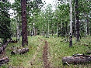
Autumn Elk by conform6073   In fact, by itself, it's not a very interesting hike at all. However, it can be combined with the East Fork Trail #95 via the Rail Road Grade, Mt. Baldy Crossover, or various bushwhacks to form loops of ten to fifteen or more miles that are quite enjoyable. While the scenery is not spectacular, it is pleasant enough, and the degree of solitude is surprising for being so near a tourist destination. The route seems to attract more equestrians than hikers, and not many of those.
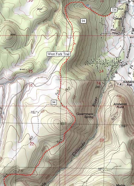
Beginning at 8,300 feet, the trail climbs moderately but steadily for 1.25 miles through recently thinned Ponderosa pine timber. It passes a small, pretty pond that seems out of place here but probably had some function a hundred years ago when Greer was a farming community. If you are to encounter any other hikers, it will most likely be in this area. The path levels out at 8,900 feet in a narrow strip of forest between the canyon rim on the left (east) and Forest Road 87 on the right. The road remains close as the way continues mainly south, and traffic on it can be distracting, both noise and dust. Abandoning the trail and walking along the rim helps but does not provide a bonus of grand views into the canyon and beyond. About three-quarters of a mile further along, the trail intersects a power line. Trees and brush have been removed under the line, and one can follow it down into town to the general vicinity of Greer Lodge. Another mile and the trail arrives at Potatoe Hollow Spring. On my first visit here several years ago, nothing indicated the trough of clear, cool water had a name; but quite a ways down the slope we spotted red paint on a board and went to investigate. It was the remains, in many pieces, of a sign which we reassembled and then read, "Potatoe Hollow". One of Dan Quale's CCC projects, we speculated. Last year a new sign appeared, and the spelling was the same, so Webster be damned, that must be the name of the place. Beyond here the trail is approaching 9,200 feet, and aspens and firs appear among the pines. This section of the trail can be quite colorful in autumn. It is also an area where we frequently encounter elk. A mile south of Potatoe Hollow the path enters a long meadow that allows views toward Sunrise and Mt. Baldy before dipping into the forest again. Arrival at a final meadow indicates the end of the trail, at the West Baldy Trail parking lot, is at hand. In fact, the path seems to terminate right at the edge of the meadow, but widely spaced posts show the way across the tall grass. From here, the shortest route back to Greer (3 miles) and the trailhead (4 miles)is along the creek. To get there, proceed straight across the meadow to the fence, thence along the fence left to the big pine tree where there's a gate, through the gate veer left and down to the path to the creek. If the intent is to link to the East Fork Trail, stay with the posts, then cross the road to the parking lot entrance. The Rail Road Trail intersects here and provides the shorter, treeless track. To reach the other option, the Crossover Trail, cross the parking lot to the Mt. Baldy trailhead and proceed along that path a mile or so to the turnoff to East Baldy Trail and Phelps Cabin. Gate Policy: If a gate is closed upon arrival, leave it closed after you go through. If it is open, leave it open. Leaving a closed gate open may put cattle in danger. Closing an open gate may cut them off from water. Please be respectful, leave gates as found. The exception is signage on the gate directing you otherwise.
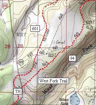
Apache - Sitgreaves FS Details If you start from the Osborne trailhead, the trail follows a small creek, which is surrounded by aspen and ponderosa pine trees. The trail takes a gradual uphill grade to Badger Pond, also known as Trail Springs Tank. Wild roses and raspberry bushes grow near the tank, offering a treat to the eye as well as the palate from mid to late summer. Past the pond, the trail splits and merges again in less than a quarter of a mile. Here comes the most difficult part of the hike as the trail rises through steep and rocky ground. It is a short climb however and the trail soon levels out. You will notice that Forest Road 87 parallels the trail for a short stretch. After leveling off, the trail crosses two dead-end roads that come off Forest Road 87. Either one of these roads offer an excellent place to park as you begin your hike. From this point to Sheeps Crossing, the West Fork Trail Image Map #2 trail is generally level, except where it makes a slight dip to Potato Hollow Spring. The spring is set in a cool stand of Douglas-fir trees and offers a perfect spot for a break. The trail continues through a checkerboard of forest and meadows. Deer are often seen browsing at the forest edge. Just a quarter of a mile from Sheeps Crossing, the trail crosses the gravel portion of AZ 273. Cross this section of road with care, as people tend to drive very fast. The trail follows an old railroad bed and ends at a parking area on the ridge above Sheeps Crossing. From this parking area, the trail becomes the West Fork Trail into the Mt. Baldy Wilderness. Notes: * Hikers, bicyclists and horseback riders are welcome, but not motorized vehicles. * Please be considerate of other trail users. * Mountain bikes are not allowed on the second leg of this trail, which is located in the Mt. Baldy Wilderness Area on the west side of Sheeps Crossing. * Bring your own drinking water, as the water sources in the area are not treated. Check out the Official Route and Triplogs. Leave No Trace and +Add a Triplog after your hike to support this local community. One-Way Notice This hike is listed as One-Way. When hiking several trails on a single "hike", log it with a generic name that describes the hike. Then link the trails traveled, check out the example. | |||||||||||||||||||||||||||||||||||||||||||||||||||||||||||||||||||||||||||||||||||||||||||||||||||||||||||||||||||||||||||||||||||||||||||||||||||||||||||||||||||||||||||||||||||||||||||||


