Route Editor

| Guide | ♦ | 3 Triplogs | 0 Topics |
details | drive | no permit | forecast | 🔥 route |
stats |
photos | triplogs | topics | location |
| 74 | 3 | 0 |
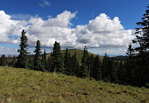
High Prairie by conform6073  Knoll - a small round hill; mound (Webster's Ninth New Collegiate Dictionary). Knoll - a small round hill; mound (Webster's Ninth New Collegiate Dictionary).Knolls abound in the White Mountains, cindery remnants of ancient volcanic activity. Most aren't notable; but a few do attract attention due to size, shape, or location, and some even have names. Greens Peak (10,133 ft.) is one such and maybe the highest knoll in Arizona. Near it are three others, all exceeding 9,900 feet in elevation, that would rank among the thirty highest named peaks in the state if they had names. Since they don't, I will refer to them as West, South, and East. These four define an elongated diamond three miles long and one wide, more or less bisected by Forest Road 117 and situated at 9,400 feet on a plain with more grassland prairie than forest. Besides their elevation, the four share a similarity of appearance, being densely timbered on their north slopes and devoid of trees on their south. The knolls' positions relative to each other suggest a loop hike, and the improvised trailhead can be anyplace you want to end. An option I haven't tried is parking atop Greens Peak, the only one of the four surmountable by car. It is also the highest, by a couple of hundred feet, and the steepest. If it's to be the fourth climb of the day, one could rationalize using the road instead of heading straight upslope. The views west, south, and east from the summit are spectacular but don't expect to enjoy them in solitude. There's a road up here because it's the site of many communications antennae and a fire tower, all of which invite much traffic. Even when no other people are around, the area is less than peaceful because air conditioning units on the communications gear kick in noisily from time to time.
West knoll (9,910 ft.) overlooks a couple of earthen tanks that attract elk and deer when the area is not overrun by cattle. From five hundred feet above, the surrounding plain appears as blank and two-dimensional as the surface of a lake, and small groves and lesser and larger knolls stand out against it in such contrast that the term "sky island" comes to mind, whether appropriate or not. South knoll (9,913) looks down on Highway 260 and south toward Big Cienega Mountain and Sunrise. At its top are a couple of primitive tables and a water catchment for wildlife. East knoll (9,947 ft.) provides great views east into Round Valley and southerly toward Antelope Mountain and Escudilla. From its peak, marked by a cairn, one can follow a game trail north and west down a wooded ridge to a skidder trail that leads to the base of Greens Peak. This area is especially lovely in late summer when monsoon rains have rejuvenated the prairie grasses and in fall when aspens on the north slopes turn. FR 117 is kept (sorta) passable in winter for access to the electronics on Greens Peak, so the four knolls route might invite snowshoers. I bet it would be gorgeous then, too. Check out the Official Route and Triplogs. Leave No Trace and +Add a Triplog after your hike to support this local community. | ||||||||||||||||||||||||||||||||||||||||||||||||||||||||||||||||||||||||||||||||||||||||