Route Editor

| Guide | ♦ | 5 Triplogs | 0 Topics |
details | drive | permit | forecast | route |
stats |
photos | triplogs | topics | location |
| 86 | 5 | 0 |
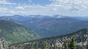
Moose Moose Grizz by LindaAnn  Turn right at the junction and head up Blacktail Lake Trail #24. The trail winds lazily up the north and west slopes of Moose Mtn. Most stream crossings have bridges. The trail is easy to follow, but vegetation does grow closely alongside the trail. Luckily, none seem to have thorns.
Now heading east-southeast, the trail becomes steeper as you begin the final mile to the summit. The views are excellent. The trail will make a sharp switchback as it gains the final ridge that leads to the summit. Hiking up the ridge is beautiful, with rocks to wind around as you enjoy airy views to the northeast. There is a large cairn at the summit, just above the left side of the trail. In the trees about 20' east of the summit is a plaque in memory of Daniel Webster VanStone, who manned the fire tower in the 1930s. A short distance east of the summit is another highpoint with even better views. After enjoying the sights, head east down the trail. You will rapidly lose elevation as the trail descends the ridge. After about 1/3 mile the trail turns north and starts to descend the bowl leading down to Moose Lake. The trail is steep as it winds downhill. My posted GPS track deviates from the official trail slightly as we were navigating through snow, but it still is pretty close to the true route. As you near the lake, the trail levels off while you hike along the west side of the lake. There are numerous camping areas around the lake, and at the northwest edge of it, a bridge and a bear-resistant food storage bin. Yes, you are in grizzly country up here. Just after the bridge is another sign leading you back to Moose Creek Trail and from the lake, it is 2 miles back to the trailhead. Leaving the lake, the trail heads north, then west, gradually downhill. You'll pass a few signs indicating how far it is to the trailhead and the junction you turned off at to begin the loop. From there, continue northwest the last half mile to the trailhead. Check out the Official Route and Triplogs. Leave No Trace and +Add a Triplog after your hike to support this local community. | |||||||||||||||||||||||||||||||||||||||||||||||||||||||||||||||||||||||||||||||||||||||||