Route Editor

| Guide | ♦ | 1 Triplog | 0 Topics |
details | drive | permit | forecast | map |
stats |
photos | triplog | topics | location |
| 0 | 1 | 0 |
Lift no more, you must hike by The_Eagle This description provides a general overview and history of the mountain, not a detailed account of a single trail. The direction pin for this area is for the main lower parking lot off of Mountain Road. There are at least 3 other trailheads. See the Trails layout below under "Trails Map".
Trails may be muddy, rocky, or slippery after rain. Some routes allow mountain bikes and ATVs; respect posted regulations and trail designations to avoid conflicts. Overview The Mount Agamenticus Conservation Region covers over 10,000 acres and contains 40+ miles of multi-use trails, including hiking, biking, and snowshoeing paths. [ Trails Map ] The trail network offers a range of loops—from short, paved summit circuits to longer moderate-to-strenuous woodland hikes. Approximately 40 miles across roughly 40 trails; here are some key named trails: Ring Trail (Popular summit loop, ~1–2 mi)
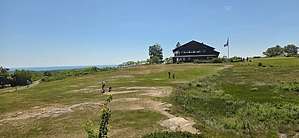
…plus numerous connector and forest trails History The summit hosted a fire tower in 1918 In 1964, the “Big A” alpine ski area opened, featuring 9 trails, a chairlift, T-Bar, rope tow, summit lodge, snowmaking, and night skiing. It operated until 1974, closing due to inadequate snow, coastal weather, and financial trouble. After failed attempts to redevelop it, the town purchased 300 acres in 1980, and conservation efforts expanded via the Land for Maine’s Future program. Today, it's a four-season recreation area with restored summit facilities and well-maintained trails. Water Sources No water on trails. There’s sometimes potable water and restrooms at the Summit Learning Lodge (open weekends Memorial Day–Indigenous Peoples Day), or bring your own. Camping No camping or fires permitted on-site. Overnight stays aren’t allowed—this is strictly a day-use area. Note There is a seasonal vehicle fee (2025 $2/hr, peak season); the Summit Learning Lodge is open weekends; dogs are allowed on leash, and horseback/bike usage is permitted on specified trails only. Synopsis Mount Agamenticus offers a versatile trail system with about 40 miles of paths through coastal forest, historic ski remnants, and scenic overlooks. It blends recreation, history, and natural beauty in an area for. Whether you're after a short paved summit loop or a multi-mile woodland adventure, the area delivers with well-marked trails, interpretive elements, and rich backstory.
Check out the Triplog. Leave No Trace and +Add a Triplog after your hike to support this local community. | |||||||||||||||||||||||||||||||||||||||||||||||||||||||||||||||||||||||||||||||||||||||||||