I have always viewed South Mountain as Hike Central for the HAZ community. So it comes as a surprise that a California guy is writing the hike description for this gem of a hike in the heart of South Mountain. I guess it shouldn't be too surprising since I posted only the 5th photoset for the hike.
This is an enjoyable hike. The lower Pima Wash (downhill from the stone house) provides a pleasant alternative to the Old Dirt Road. It's also much less crowded. The wash meanders through the mostly sandy wash with occasional rocky inclines. For the most part, it's pretty flat. A little before the stone house, you have to exit the wash and head up to the Old Dirt Road because the wash is closed.
Past the stone house, you can reenter the wash and continue up the wash. From here on, the wash is enclosed in a canyon bordered to the south by Guadalupe Ridge and to the north by the National Trail. The beginning of this leg of the wash is much like the lower leg, mostly flat. However, the wash gets narrower. Eventually, the trail reaches a rock wall. The first involves about a 40-foot climb, followed quickly by another 60 feet of quick elevation gain.
Route finding to this point hasn't been too difficult. Then you arrive at a much bigger 80-foot climb that I struggled to figure out a good approach to. I finally settle on some slippery rocks on the left side of the wall because they seemed to have good handholds. I scrambled my way up to be faced with yet another wall ahead. This is where I exited the wash briefly in favor of a higher route up near Guadalupe Ridge.
After a while of hopping from rock to rock, I ran into a well-worn trail that took me back down to the wash, above all of the rock wall scrambling. The remainder of the canyon is relatively flat until just before your reach the cave at Hidden Valley. Then you have some rock scrambling to do again before reaching the cave and exiting Pima Wash.
When hiking several trails on a single "hike", log it with a generic name that describes the hike. Then link the trails traveled, check out the example.
WARNING! Hiking and outdoor related sports can be dangerous. Be responsible and prepare for the trip. Study the area you are entering and plan accordingly. Dress for the current and unexpected weather changes. Take plenty of water. Never go alone. Make an itinerary with your plan(s), route(s), destination(s) and expected return time. Give your itinerary to trusted family and/or friends.
Permit $$
None
Directions
Road
Paved - Car Okay
To Pima Canyon Trailhead To Pima Canyon Trailhead
This one is a little tough to locate if you're not from the area. It's near Guadalupe Rd. The issue at hand is there are no on-off ramps for Guadalupe Rd. Instead, get off south a mile on Elliot and follow 48th Street north.
Pima Canyon Trailhead is located west off of 48th Street, just south of Guadalupe Road. It's all somewhat confusing. Your first time, go to the intersection of Guadalupe & 48th, then head south. Take the first right and an immediate left into South Mountain/Phx Preserves Park. Follow the access road passing the golf course all the way to the trailhead.
Pima Canyon Trailhead and Marcos de Niza Trailhead are the same now. Long ago, the road continued to Pima Canyon Trailhead.
From PHX (I-10 & AZ-51) 10.9 mi - about 18 mins From TUC (Jct 1-10 & Grant) 101 mi - about 1 hour 32 mins From FLG (Jct I-17 & I-40) 155 mi - about 2 hours 25 mins
 Route Editor

 I have always viewed South Mountain as Hike Central for the HAZ community. So it comes as a surprise that a California guy is writing the hike description for this gem of a hike in the heart of South Mountain. I guess it shouldn't be too surprising since I posted only the 5th photoset for the hike.
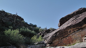


