|
tap row or icons for details
|
| Difficulty |
|
1 of 5 |
| Route Finding |
|
2 of 5 |
| Distance Round Trip |
|
1.3 miles |
| Trailhead Elevation |
|
4,536 feet |
| Elevation Gain |
|
360 feet |
| Avg Time Round Trip |
|
1 hour |
| Kokopelli Seeds |
|
3.1 |
|
| | |
|
|
13 |
2024-12-08 | hippiepunkpirate |
|
|
30 |
2021-05-27 |
Thunder Mountain Loop plus high points |
tibber |
|
|
|
8 |
2019-04-28 |
Little Sugarloaf |
trekkin_gecko |
|
|
|
2 |
2014-04-22 | fricknaley |
|
|
8 |
2014-04-05 |
Capitol Butte South Face aka Thunder Mtn |
sbkelley |
|
|
|
4 |
2014-04-05 |
Capitol Butte South Face aka Thunder Mtn |
neurolizer |
|
|
|
8 |
2007-05-15 | Sjcorrea |
|
|
5 |
2005-10-31 | kevin1959 |
|
| |
|
|
list |
map |
done |
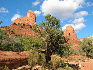
Sedona Region |
| | |
|
| |
|
|
Historical Weather |
| Trailhead Forecast | | |
|
 |
|
|
| Preferred Mar, Nov, Apr, Feb |
|
|
|
Seasons Spring to Early Winter |
|
|
| | |
Named Locations Coordinate Links
| |
|
|
Chimney Rock - Sedona
|
2.04 mi
376 ft |
 |
|
Thunder Mountain Loop plus high p...
|
5.41 mi
1,154 ft |
|
| Little Sugarloaf
|
2.89 mi
538 ft |
|
|
| Capitol Butte South Face aka Thun...
|
4.2 mi
2,325 ft |
|
|
| | |
| |
|
|
Happy Trails!
 area related
Wilderness Map  wilderness related  region related
2021 Verde Valley Trails  region related
2021 Verde Valley Area  region related
2021 Sedona Trails Map
|
 Route Editor


